Contents
Year after year we dream of a white Christmas, but the reality is different. We have never experienced a white Christmas since 2010. Most of the time it was almost spring-like mild. This year the south was extreme: in Biasca it was 21.8 degrees, and December 24th was the warmest.
Legend:
Springy Ticino
In Ticino it was already more than 20 degrees on Saturday, and on Christmas Eve with the north foehn it was warmer than ever on December 24th.
Werner Caviezel
The tragedy has a tradition: almost every year it is extremely mild, especially over Christmas. This year the southern side of the Alps is particularly affected. On the afternoon of December 24th, the temperature rose to 21.8 degrees in Biasca and 20.8 degrees in Cevio in the Maggia Valley. However, both stations have only been in operation for a few years and cannot yet be used for a climate comparison. The situation in Stabio near Chiasso is different. 18.9 degrees were measured there. It was never so warm there on December 24th. The old high was from 2018 at 16.3 degrees.
It was also the warmest December 24th at practically all other measuring locations in Ticino, including in Lugano, where measurements have been taken for more than 100 years. There were also new highs for December 24th in southern Bünden, for example in Poschiavo with 15.6 degrees or in Sta. Maria in Münstertal with 11.8 degrees. There were also new records for Christmas Eve at the Ofenpass and in Samedan in the Upper Engadine, where the temperature was 8.9 degrees.

Legend:
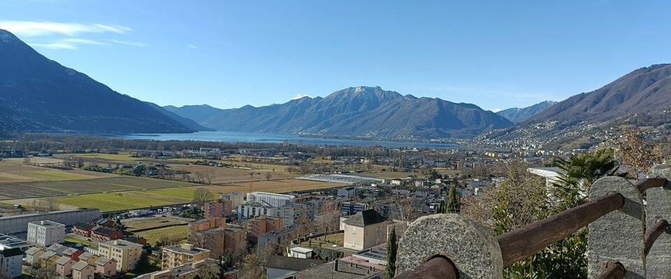
Almost like summer
View from Ascona to Lake Maggiore with a few high clouds.
Martina Ziegler
There is a system to the debacle
The weather pattern we have experienced over the last few weeks is systematic. At the end of November, the polar night begins in northern Scandinavia and a cold peak forms. As a result, icy air often pushes into Central Europe from the north. Accordingly, snow falls down to low altitudes at the end of November or the beginning of December, and snowfall is also not uncommon in mid-December. Some of the cold air flows into the Atlantic, which was very mild at the time. These are optimal conditions for the formation of strong low pressure areas over the nearby Atlantic.
For us, shortly before Christmas or at the beginning of the festive season, they usually lead to a southwest to westerly flow with a noticeable onset of warmth and a thaw. This is why we speak of the so-called Christmas thaw. The snowfall line is often well above 1500 meters, this year on Christmas Eve it was even between 1800 and 2300 meters.
Hit rate is 70 percent
In Germany, the big thaw usually occurs between December 22nd and 28th, but here it tends to happen a little earlier. This year it even became mild 10 days before the festival. On the other hand, purely statistically speaking, winter often returns in Switzerland during the festive season. Snowfall has often occurred on St. Stephen’s Day, but this year it will probably only happen at the turn of the year, if at all. Purely statistically, there is a 70 percent chance that there will be a Christmas thaw in Germany. In Switzerland there has not been a year without a classic Christmas thaw since 2010.

Legend:
Christmas Eve 2015
On Christmas Eve 2015 it didn’t really look wintery in Saas Fee.
Ueli Klossner
The balance of horror
In 2010 there was a widespread white Christmas in the Mittelland for the last time, despite the Christmas thaw. On December 17th, 30 centimeters of fresh snow fell in some parts of the Mittelland. By December 22nd, however, the white splendor was gone, and it wasn’t until December 24th that snow began to fall again. From then on, Christmas heat records were set: in 2011, +6 degrees were measured on Mount Pilatus, but already on December 23rd. On Christmas Eve there was a storm of 130 kilometers per hour. In 2012 it was 20.2 degrees on Christmas Eve in Reigoldswil (BL), while in St. Gallen it was 15.4 degrees, the local maximum for Christmas Eve. On December 24, 2013, 17.1 degrees were registered in Basel, which was never this warm there before on Christmas Eve. In 2014, almost 10 degrees were measured in Basel on Christmas Eve.
Already on December 23rd it was more than 14 degrees in Adelboden and on the Jura heights. In 2015 it was Basel’s turn again with a maximum of 15.0 degrees. Double-digit plus temperatures were also recorded in the Bernese Oberland in 2016, and in 2017 there was T-shirt weather, especially in the mountains. +7 degrees were measured on Mount Pilatus on December 25th. In 2018 it was a good 13 degrees again on Christmas Eve in Basel, and in 2019 more than 11 degrees were measured in northwestern Switzerland. Otherwise, the temperatures exceptionally corresponded to the long-term average, but more than 16 degrees were measured in Ticino at Christmas.
In 2020 it was 16.5 degrees in Basel on December 22nd and a good 10 degrees on Christmas Eve, but on December 25th it snowed into the lowlands. In 2021 it didn’t get milder again until Christmas, but a week later it was record warm. Last year, Schaffhausen experienced the second warmest December 24th at 11.5 degrees, and the rest of Switzerland was also extremely warm both at Christmas and especially at the turn of the year.

Legend:
Lenzerheide on St. Stephen’s Day 2020
There was also little snow in the Alps over the festive period in 2020.
Achim Sauer
2015 and 2016: Green Christmas also in the Alps
The situation in the mountains in 2015 and 2016 was very dramatic. Back then, nothing could melt with the Christmas thaw. Almost everything was gone. Even at high altitudes there was hardly any snow. On Christmas Eve 2015, the total snow cover in Davos was only 2 centimeters, and a year later, like most places in the Alpine region, it was just completely green. The situation is currently quite comfortable with 81 centimeters in Davos-Dischma and 97 centimeters in Arosa.

Legend:
It’s winter here
December 24th: There is 81 centimeters of snow in Davos-Dischma.
Gilbert Zellweger
Only noticeably cooler at the turn of the year
Things continue to be very mild over Christmas and also in the New Year’s week. Temperatures of around 7 degrees are measured at 2000 meters above sea level on both Christmas and Thursday, and it is only at the turn of the year that various weather models show a significant cooling. Even snow down to the lowlands is not ruled out, but the final word has not yet been spoken, especially since the atmosphere is very dynamic at the moment.