The bursting of the dam on the Dnipro not only forces a devastating flood catastrophe on Ukraine. The outflowing water could also influence the further course of the war. A huge open flank is developing at the Zaporizhia nuclear power plant, as satellite photos show.
The flood disaster in the south of Ukraine leads to massive changes on the Dnipro. The Kachowka reservoir, which was once 230 kilometers long, is draining unhindered after the dam at Nowa Kachowka broke.
A full week after the barrier was destroyed, much of the vast expanse of water between Nikopol on the north bank and Enerhodar on the south has disappeared, recent satellite photos show.
This creates a completely new situation for the Ukrainians on the north bank and for the Russian occupying forces on the south bank of the Dnipro. Until now, they were separated from each other by a huge expanse of water at the Kachowka reservoir.
Within a week, however, the water level has fallen by a good eight meters. The reservoir is almost completely empty between Nikopol and Enerhodar. According to estimates, the largest reservoir in Ukraine to date has lost more than 70 percent of its water masses and is starting to dry up from the edges. Large areas of the lake bed lie open in the sun.
The images from space show how a new, largely uncovered section is emerging in the middle of the approximately 1000-kilometer-long front in Ukraine. At the level of the Zaporizhia nuclear power plant (link to map), the reservoir was five to ten kilometers wide until recently.
Now, in the middle of the emptied reservoir, the Dnipro retreats into a new, narrow and heavily tortuous river course. At the narrowest point, the remaining stream appears to be only a good 400 meters wide.
Since the end of last week it has been clear: the cooling basin of the nuclear plant is cut off from the fresh water supply. The six reactor blocks are shut down. However, the power plant still needs water for cooling on an ongoing basis in order to prevent a possible core meltdown.
experts of Atomic Energy Organization IAEA assume that the amount of water stored in the pool should be sufficient for “several months” for cooling. However, all hopes rest on the fact that the dam of the reservoir will not be damaged – and that the nuclear power plant will not get caught between the fronts in the coming months.
However, this is to be feared: before the dam burst, the reservoir was between five and ten kilometers wide at this point. The Russian military has been stationed on the south bank since the first weeks of the war, and they also control the site of the nuclear power plant there. The closest Ukrainian positions so far are on the north bank east of Nikopol.
The collapse of the dam not only endangers the cooling water supply for the nuclear power plant on the south bank of the reservoir. The catastrophe could also change the military situation in the region: As the war progresses, the terrain created could create a new operational area on the uncovered flank of the Russian army. The emptied reservoir could sooner or later become part of the combat zone.
According to reports, the south bank of the Kachowka reservoir was previously comparatively weakly fortified. So far, the Russian military has only had to fear attacks by Ukrainian commando units with boats. After the dam burst, the increasingly wide strip of shore appears to have been exposed. In order to secure this area, the Russians would have to move further troop contingents to a section of the front that has been largely quiet up to now.
The most recent images from the region come from the European earth observation satellite Sentinel 2 and were taken on June 13: The nuclear power plants at Enerhodar are on the bottom right of the image and are partly covered by clouds. The comparison photo, on the other hand, is from June 5th: You can see the situation at the reservoir immediately before the dam burst.
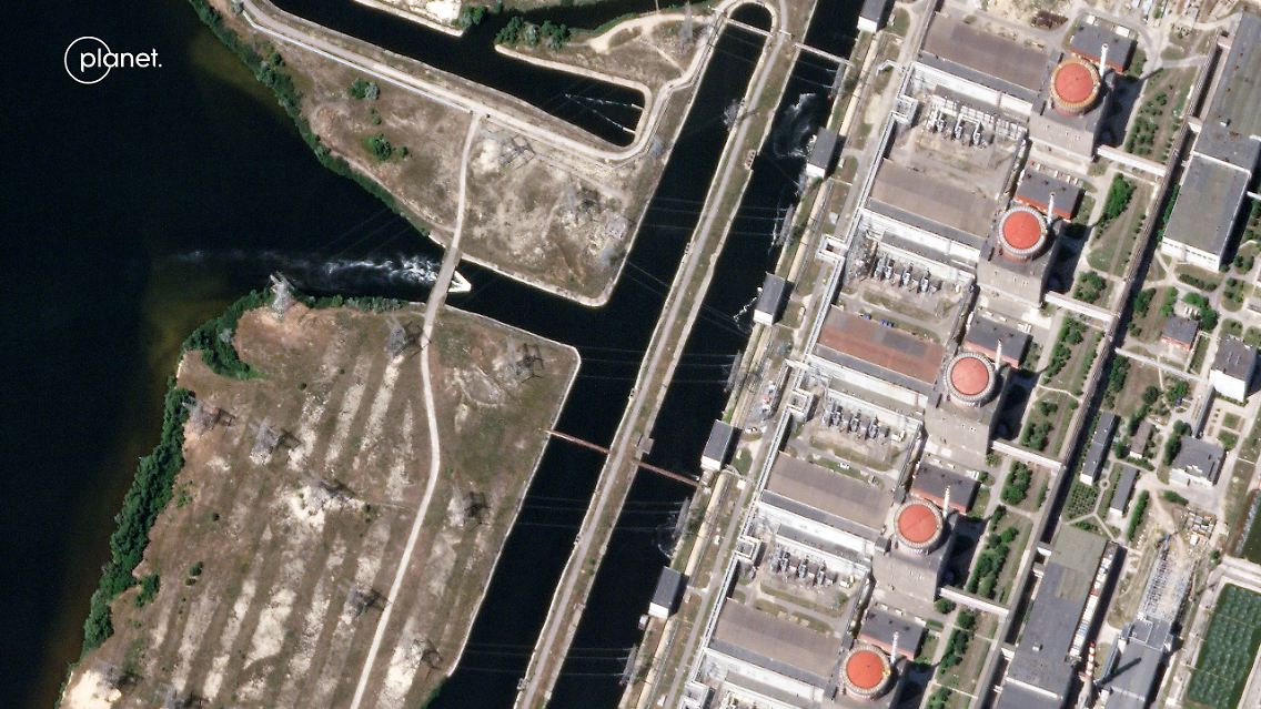
Cooling water reservoir at the Zaporizhia nuclear power plant: This greatly enlarged detail of a satellite image shows the nuclear power plant on June 9th under a cloudless sky.
(Photo: © Planet Labs GmbH)
The destruction of the dam at Nowa Kachowka reveals land that has been under water for nearly seventy years. In summer weather conditions, the sometimes muddy subsoil could soon solidify. After all, before the flooding in the 1950s, there was mostly solid ground here with streets, courtyards and entire settlements.
The Kachowka Dam itself is not in the picture in this section. The remains of the dam lie about 120 kilometers downstream to the southwest. The remaining water in the empty reservoir continues to flow away. The destroyed dam at Nowa Kachowka can no longer hold back the Dnipro. And: That won’t change anytime soon. The breaches are too big to repair quickly. In addition, the dam is still in no man’s land between the fronts.
As a result, the Kachowka reservoir will continue to dry up. The operator of the Ukrainian hydroelectric power plants has also announced that it will reduce the discharge at the other dams on the Dnipro. Ukrhydroenergo’s stated intention is to store water for power generation next winter.