Picture: Google.
Every day, millions of people use Google Maps, not only to find their way, but also to give their opinion on the places they have visited.
Internet users post photos, leave comments and answer questions from other users. Collectively, they collectively help each other get to know a place better.
Available for Android and iOS, Google Maps is an efficient geolocation mobile application that allows you to know where you are, and define where you want to go in order to lead you there.
- Downloads: 10
- Release date : 09/27/2022
- Author : Google LLC
- Licence : Free License
- Categories:
Leisure – Travel - Operating system : Android – Online service All Internet browsers – iOS iPhone / iPad / Apple Watch
So Google decided to use this wealth of information to give an idea of the atmosphere of a neighborhood. The web giant also announced other new features for its navigation application.
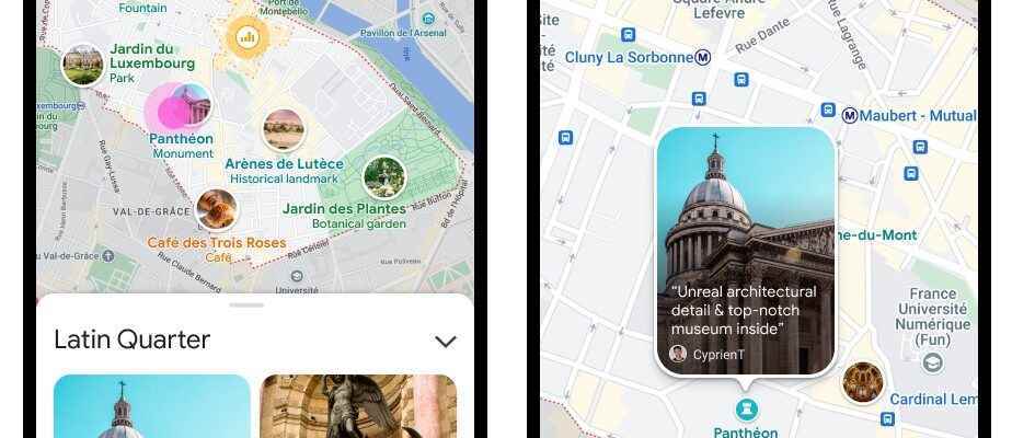
Discover the vibe of your neighborhood
The new function, which will be called “Neighborhood vibe” (“neighborhood atmosphere” in French, Editor’s note) will above all make it possible to “quickly identify what is interesting in an area”, explained this week to the press Chris Phillips, head of Google GEO.
The choice of places popular enough to feature in the Neighborhood vibe feature will be made by an algorithm. But Google will also rely, at least initially, on comments made by users to ensure that the service offers quality results. However, when the product becomes available worldwide, functionality will have become technological.
Neighborhood Vibe will begin rolling out globally on Android and iOS in the coming months.
“The most complete and up-to-date map”
When you open the Google Maps app, popular and trending places around you are highlighted on the map, whether it’s a cafe, bar, park… app offers you places that other users have rated as important.
And every day, Google Maps users add millions of updates to the application, says Chris Phillips, before specifying that “the product has adapted and developed to help users explore the world and get around better. “.
For him, the 17-year-old application offers “the most complete and up-to-date map possible”. To do this, Google combines “authoritative imagery and data sources”, adding information gathered by the user community.
New on Live View
Google is also developing Live View, a feature first introduced in Maps in 2019. It uses augmented reality to overlay app elements onto reality. For this, the feature uses machine learning, smartphone sensors and real-world images provided by the Street View feature. The service helps determine which direction to take at the start of a walking route.
Today, Google is launching the “Search in Live View” function to help users quickly identify places of interest in front of them.
For example, says Chris Phillips, if you’re in an unfamiliar area and need cash, you can search Google Maps for ATMs nearby. Using the Search in Live View feature, “just raise your camera, tap the icon in the Google Maps search bar and see directly, superimposed on the real world, the ATM that is near “.
The extension of the service will be rolled out in the coming months.
Green routes for third-party apps
For a few months, Google Maps has been offering “ecological routes” that allow you to save fuel when traveling in a motorized vehicle. Last Wednesday, Google announced that it would make this feature available to developers of the Google Maps platform. Thus, companies that use the application, for example for their drivers (VTC, carpooling, delivery people, etc.) will be able to benefit from this service to save fuel.
“It is also a way to extend the ecological benefits of this product beyond the users. [privés] of Google Maps, to the developer community,” says Chris Phillips.
Eco-routes were launched in Google Maps last year in the United States and Canada. This feature offers drivers routes that are not necessarily the shortest route from point A to point B, but which should result in the lowest possible carbon emissions.
Last May, Google reported that its users had already used the feature to drive 86 billion miles, saving around half a million tons of carbon emissions, the equivalent of removing 100,000 cars from the traffic.
The eco-routing feature will be available to developers using Maps’ mobility offering, Google Maps Platform. It should be made available through the free part of the platform. A preview will be available by the end of the year.
Earlier this year, Google also extended the eco-routing option to its Google Flights service, letting its users know the expected carbon emissions of an airplane journey, alongside other information like the price of the ticket or the flight schedule.
Source: ZDNet.com [1, 2]