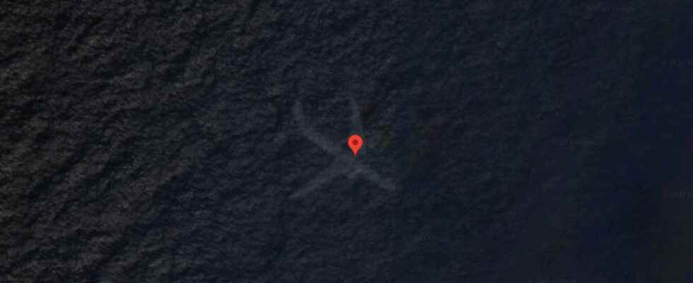
Once again, a Google Maps find on Reddit causes a stir. This time, a plane in the sea near the Bahamas is causing discussions in the community.
The Reddit community spotted a plane in the sea off the Bahamas on Google Maps. (Source: Google Maps/Terra Metrics, Maxar Technologies, map data)
With Google Maps you can not only get from A to B quickly, but you can also see the world from a satellite perspective. This often leads to strange but also spectacular discoveries. The Reddit user with the pseudonym “u/ExuberantBadger” has now shared one.
You can view them by entering the following coordinates into Google Maps: 22.6783072, -73.8283369. If you then activate the satellite view, you will see the outline of an airplane in the sea. Did Google Maps catch a plane crash not far from the Bahamas?
No! This is probably a photo error. Google puts the satellite view together from several images, and when they are added together, artifacts can remain, which then trigger associations in our minds. Another Reddit user with the pseudonym “carlitosbahia” looked at older photos of the position on Google Maps and here the plane can be seen in flight.
picture series
Google Maps Mysteries: What’s Really Behind These Satellite Images
Google Maps Mysteries: What’s Really Behind These Satellite Images
There is also a simple explanation for this giant snake off the French coast. This Google Maps find, on the other hand, actually brought a tragedy to light.
Don’t miss anything with the NETWORK-Newsletter
Every Friday: The most informative and entertaining summary from the world of technology!