- The storm “Antonia” brought gusts of wind between 80 and 110 km/h in the lowlands. On the mountains he was even stronger. The strongest gust so far was measured in Bad Ragaz at 112 km/h and on the Chasseral at 164 km/h.
- Temporarily it will be a little quieter, but strong gusts of wind are possible again in the afternoon and evening.
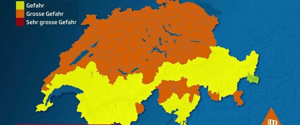
- The strongest winds moved across the lowlands on Monday morning with the cold front. The federal government warned of significant dangers due to gusts of wind and strong winds in the mountains.
- At these wind speeds, trees could also fall, according to the federal natural hazards portal.
Legend:
SRF Weather
The storm “Antonia” crossed large parts of Switzerland during the night. According to SRF Meteo, even stronger gusts with wind speeds of over 100 kilometers per hour followed on Monday morning. In the afternoon the storm should gradually subside. In addition, it is changeable, with sometimes heavy rain and snow showers, and short sunny phases, with up to 7 degrees. In the south it will be partly sunny with highs around 15 degrees.
According to that Federal natural hazards portal In the mountain regions there is still “considerable danger” until Monday afternoon, which corresponds to danger level 3. From 2 p.m. there is still moderate danger in the lowlands (danger level 2).
The storms could sweep away objects, loosen roof tiles, topple trees and cause high waves on the lakes. “In stormy winds, you should therefore avoid spending time outdoors if possible,” advises the federal government.

Legend:
“Antonia” not only caused dark clouds like here in Bern.
SRF eyewitness / Katrin Aeschlimann
Two accidents and breakdowns in mountain railways
There were two accidents in the canton of Bern. Cars collided with trees that had fallen on the road. According to the findings of the Bern cantonal police, no one was injured. Both accidents occurred in the Bernese Mittelland, as a police spokeswoman said. Eleven reports of storm damage were received across the canton.
Current traffic information
According to Railinfo, some cable cars were also out of service due to the wind, including from Weggis LU to Rigi Kaltbad, the Titlisbahn above Engelberg from Stand to Titlis, the cable car from Unterterzen SG and Flumserberg Tannenboden and from Adliswil ZH to Felseneg ZH. In the morning, the trains between Weissbad AI and Wasserauen AI were canceled – probably until the end of the day.
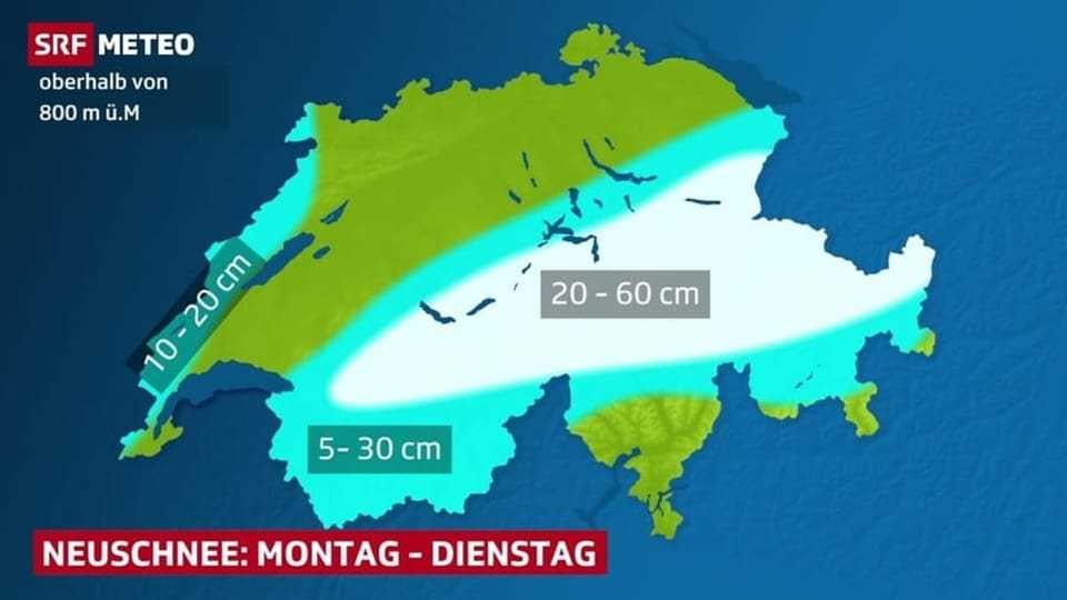
Fresh snow and increasing danger of avalanches
Legend:
SRF Weather
The cold front associated with the storm will also bring rain and snow, as reported by SRF Meteo. In the Alps above 800 m altitude, 20 to 60 cm are expected until Tuesday. Local differences will be large due to snowdrifts. The stormy wind can cause heavy loads and the risk of avalanches increases accordingly. According to that Avalanche bulletin from the Institute for Snow and Avalanche Research SLF from the early morning, there is a considerable avalanche danger in some cases.
In the last few days, the storms “Ylenia” and “Zeynep” have already swept across Switzerland and Europe, with some major effects.