The National Institute of Geographic and Forest Information (IGN) announced at the beginning of the summer a new project, in consultation with the government, to produce land use data automated by artificial intelligence.
The objective is to cover all of France by 2024 via this process. The IGN intends to achieve this with data “coherent at the national level” and “delivered at close intervals, and in close consultation with the territories” said the institute in a press release.
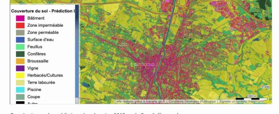
The IGN is working to describe the occupation and use of the land, within the framework of the Observatory of the artificialization of the soil, a program launched in collaboration with the CEREMA (Centre for studies and expertise on the risks , the environment, mobility and development) and INRAE (National Institute for Agricultural Research). What emerges is a repository of geographical data, according to the “OCS GE nomenclature” (large-scale land use), specifies the IGN.
The resources of the Gers department are already available via this process to date. This is the first department carried out within the framework of the national provision for measuring soil artificialisation.
Digital Commons
Concretely, the IGN uses AI and deep learning to automate its initial production chains and updates of geographic data that describe land use. Deep learning methods make it possible to automatically recognize objects, such as trees or buildings, on aerial or spatial images.
In a second step, a new deep learning model called “whole France” will be trained on the basis of the annotations distributed over the whole territory and will make it possible to generate predictions as well as OCS GE products.
In addition, the institute announces that it makes available its resources which contribute to the automated process, “in a process of common enrichment”. Thus, everyone can access annotations in particular, i.e. the data used to train deep learning models, deep learning data sets or even deep learning prediction maps.
IGN and its partners aim to cover the metropolitan territory and the overseas departments and regions by 2024. The datasets will be gradually disseminated here.