
Genevieve Donnellon-May, a master’s student at Oxford University, is an expert on water and food security issues in China. She regularly contributes to several journals, including The Diplomat.
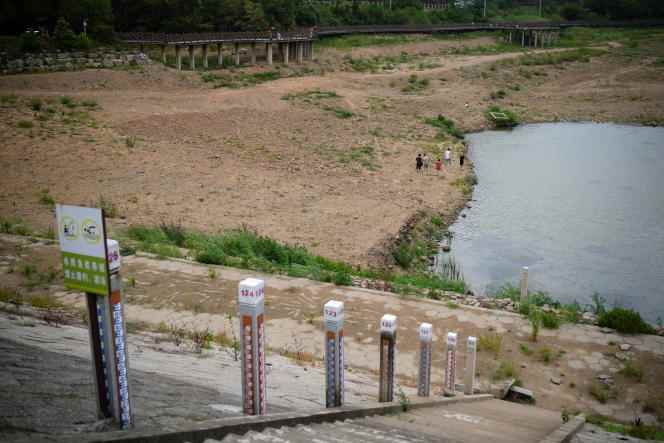
China experienced an exceptional drought in the Yangtze River basin this summer. How does this local phenomenon concern the whole country?
Water poses significant and interrelated problems for China: the quantity of water (China holds only 6% of the world’s water reserves), but also its quality and its distribution are extremely problematic. Thus, it is estimated that the north of the country, both highly populated and highly agricultural, has 25% of the population, 27% of the gross domestic product, but has only 4% of the country’s water resources.
Northern China is also dependent on groundwater, which provides 50% of industrial water needs, 33% of irrigation water and 65% of water for domestic use. But this exploitation of groundwater has led to a significant drop in water levels in aquifers across the country. The aquifer in northern China is one of the most overexploited in the world. Due to intensive agriculture and the development of irrigation, much of the shallow aquifer has shrunk by twenty meters in recent decades, even by forty meters in places.
You mentioned a water quality problem…
Yes, existing water resources are highly polluted. A study conducted by the Chinese government in 2016 indicates that 80% of groundwater is contaminated with pollutants, including heavy metals or arsenic.
To fill the water deficit in the north of the country, Mao wanted to transfer part of the water coming from the south there. Was this project completed?
Mao said: “The South has a lot of water, the North, much less. The North should borrow some. » So China set out to build a megaproject: the South-North Water Diversion Project. To do this, it takes three routes. The eastern route transfers water from Jiangsu to Shandong and Tianjin, through the Grand Canal that has linked Hangzhou to Beijing for nearly 2,500 years. The central route starts from Hubei and brings water to Beijing and Tianjin. It has been in operation since 2014. The western route remains to be built, for which there is an official plan, but also alternatives.
The official plan, which calls for connecting the Yangtze to the Yellow River via the Qinghai-Tibet Plateau, would divert 17 billion cubic meters of water annually. It’s massive, but less than the alternatives. The first evokes the construction of a dam in Tibet which would make it possible to divert each year 200 billion cubic meters of water from Sichuan to bring it to Beijing. But this seems neither feasible nor necessary. Another, semi-official option, issued in 2017 by a team from Tsinghua University, is causing a lot of talk: it consists of diverting 60 billion cubic meters of water each year from the rivers of the Qinghai-Tibet plateau, including three rivers international networks, the Mekong, the Salouen and the Brahmaputra, to bring it to the northwest of China, particularly to Xinjiang.
You have 37.59% of this article left to read. The following is for subscribers only.