The weather is remarkably capricious: after the continuous rain of the past few days, glorious sunshine with spring-like high temperatures is the order of the day.
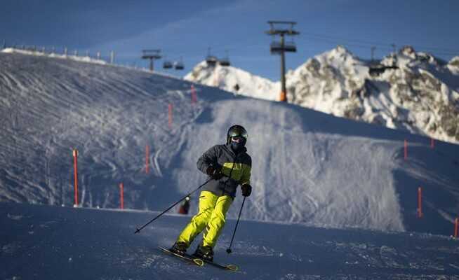
Skiers enjoy the mild weather like here in the Pizol ski area above Bad Ragaz.
It doesn’t look wintry at the turn of the year. The thermometers today will show almost record high mild temperatures. According to Meteo Switzerland it gets up to 13 degrees warm in the afternoon in the lowlands. In the mountains with moderate westerly to northwesterly winds, temperatures of 9 degrees can be expected at 2000 meters. The zero degree limit is at 3200 meters. At midnight you should be able to toast the New Year on the balcony without thick winter clothes.
The turn of the year will be warm above average. However, record highs are unlikely to be reached. As a Overview from Meteonews shows, temperatures of more than 16 degrees were measured on New Year’s Eve and New Year’s Eve. The reason for the current high temperatures is the high altitude jet stream, which moves the air masses in the deeper layers and brings warm air, sometimes even from the Caribbean.
Wonderful weather until Sunday
The forecasts for New Year’s Saturday and Berchtold Sunday remain practically the same. Glorious sunshine is the order of the day almost everywhere, only in the lowlands there are still fog or high fog fields in the morning, which dissolve in the afternoon at the latest.
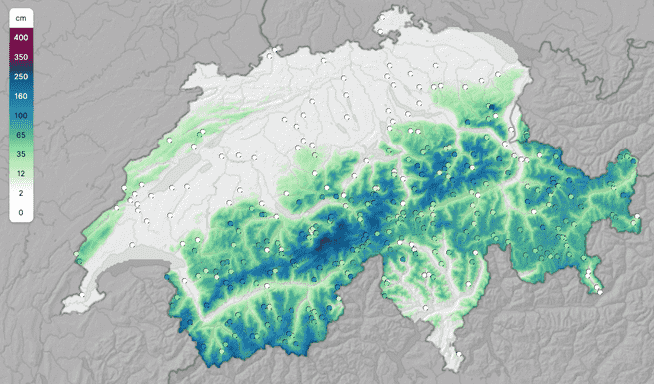
In the lower elevations of Switzerland you have to say goodbye to the snow. It has been swept away by the constant rain of the past few days. What was left is likely to melt away due to the high temperatures. Even in very high ski areas, such as the Vorab glacier at over 3000 meters or the Upper Engadine Corvatsch, temperatures above freezing point can be expected. Sub-zero temperatures only exist in higher altitudes, for example on the Klein Matterhorn (3883 meters). Here the temperatures rise to minus 1 degree.
Nevertheless, it should be enough for skiing in most ski areas. Because the slopes have been groomed in the past few weeks so that they will hold up despite the snowmelt. As a Overview by Bergfex shows, most of the systems are in operation. However, up to 1500 meters you can expect quite wet and soft slopes. Especially in the Central Alps and in the Valais still lies a lot of snow:
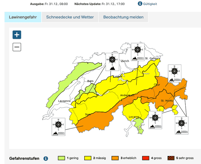
Considerable avalanche danger
The avalanche situation remains delicate, even if the danger has become less precarious compared to the previous days. Due to the precipitation, the snow cover is soaked through up to high altitudes or has become damp at least in the layers close to the surface in the area of the snowfall line. The warm and damp snow settles quickly and is therefore more stable. However, the new snow and drifting snow from the central Valais via northern Ticino to Graubünden lies on weak old snow and remains prone to failure at altitude, as in the Avalanche bulletin for New Year’s Eve is called. The avalanche danger is assessed as considerable (level 3 of 5), especially in the main Alpine ridge from Valais via Central Switzerland to Graubünden. Level 2 (moderate) applies in the Northern Alps.
Warm and mild elsewhere too
The past winter also showed drops: According to Meteo Schweiz, winter 2020 was one of the ten mildest since measurements began in 1864, which was particularly due to the comparatively warm February.
Not only is the Swiss winter warm and wet, in the past two decades such onset of winter has become more frequent in Alaska, for example. Record daily temperatures of over 15.5 degrees have been recorded there and torrential rains have been reported, as “The Guardian” writes. It usually snows at this time of year and it is bitterly cold. In several communities, the rain turned to ice because of the cold roads, which led to road closures and power outages. The authorities speak of «icemageddon».
The newspaper quotes a study from the journal “Nature Communications”. Accordingly, the authors predict an arctic climate with more winter rain than snowfall from the year 2060 or 2070. The cold winters in Alaska will remain, but warm, humid periods will occur more frequently.