Its satellite images have documented one of the first Russian military convoys, shown the damage in Mariupol or helped support the accusations of war crimes in Boutcha. Maxar Technologies illustrates every major step in the conflict, but what is this company?
The horrors of a war visible from space. Published Monday, a series of satellite images calls into question the Russian assertions concerning the massacre of Boutcha (Ukraine). Accused of war crimes and crimes against humanity, Russia has so far maintained that the corpses of civilians found in this city had been placed after the departure of its troops. It was without counting on the images of Maxar Technologies, attesting to the presence of bodies in the streets… since mid-March. And, since the beginning of the war, this is not the first time that the American company, specializing in satellite imagery, has been talked about.
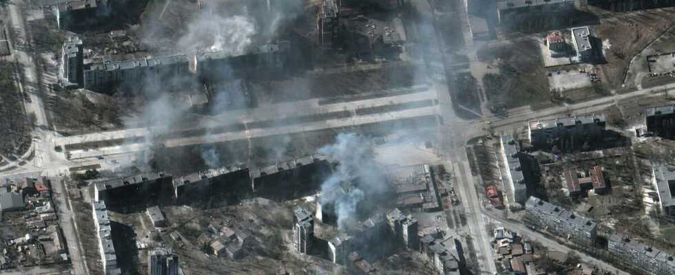
From February 28, his photos, illustrating the advance of a huge Russian convoy, allowed Ukraine to anticipate the preparation of a massive assault on Kyiv. About ten days later, a photo of a bombed theater in Mariupol, at the foot of which the word “children” was written, outraged the world. The same goes for other series of images, highlighting the extent of the damage in the port city or in Kyiv.
Ukrainian civilians wrote the word “children” on the ground outside a drama theater in the besieged city of Mariupol where hundreds of civilians are hiding – pleading Russian pilots not to bomb.
Russian forces ignored the pleas, bombing the theater earlier today.
?:@Maxar pic.twitter.com/CgTYBUsHbu
—Jack Detsch (@JackDetsch) March 16, 2022
“It is not the first time that images taken from a distance have played a role in a conflict, analyzes Anne Puissant, professor at the University of Strasbourg in geography and geomatics. The difference with the Maxar images is that they are much more publicized because they are more accessible to the public, where previously they came rather from military satellites and remained secret-defense.
The reason ? Maxar is a private American company, based in Westminster (Colorado). Appeared in 2017, it brings together the activities of four subsidiaries. A specialist in the construction of satellites: SSL. Another in 3D geospatial analysis: Vricon. Radiant Solutions is dedicated to modeling satellite data. And, finally, DigitalGlobes, allows to produce high resolution satellite images. The latter, for the record, is even one of the first companies to have developed very high resolution commercial satellites, such as Ikonos (2000) or QuickBird (2001). Satellites which subsequently fed the first images of Google Earth or Google Maps.
Maxar, stronger than the clouds
According to its own figures, the company would thus have 90 satellites in orbit, scanning the surface of the Earth with, for some, a resolution of 30 centimeters. “This means that one pixel of the images produced represents 30 centimeters on the ground”, explains Anne Puissant. Not enough to formally identify individuals on the ground, therefore, but enough to find use in a whole range of fields. Like the environment, by following the evolution of certain cultures or that of the artificialization of the soil. Town planning, by helping to identify the location of car parks, for example. This technology can also be used to document natural disasters, such as the eruption that occurred in Tonga in January.
Thus, military use is only part of Maxar’s business. But a part which, with the war in Ukraine, has gained momentum. “Its images make it possible to observe the state of advancement of the troops, to have an objective vision of a territory, to recognize the equipment used…” lists the expert. A capacity all the more interesting as the company with 4,400 employees is able to provide snapshots of 3.8 million square kilometers of territory every day. “Before, we could only have images of the same territory every 15 or 20 days. But, now, with the multiplication of the number of satellites in orbit since the 2000s, it is daily.specifies Anne Puissant.
And if you were wondering: yes, even in cloudy weather, the company can provide images thanks to so-called “radar” satellites. Enough to bring some clarity to its share price, which has been growing rapidly since the start of the Ukrainian conflict. Listed on the New York Stock Exchange, the company has seen it rise rapidly in recent weeks, rising from $24.50 on the eve of the invasion to $35.60 on March 2, a 45% jump in one week. Today, it is around $38, with a market capitalization of $2.84 billion.
The United States as a main customer
In addition to industries, Maxar therefore counts some fifty governments among its clients. The main ? That of the United States, which would even decide which areas to observe. Hence the time spent by the company’s satellites over Ukraine. In addition, according to the Maxar site, it would provide “90% of basic geospatial intelligence used by the U.S. government for national security and to keep troops safe in the field.” And would also intervene in the field of space research… As during the Perseverance mission, the rover sent to Mars by NASA.
And even though Maxar is among the oldest and most powerful companies in the business, the US government also relies on many of its competitors. Like Capella Space, a start-up based in San Francisco, which provides data to the United States and Ukraine and manages to announce certain Russian military operations in advance. Or Planet – more than 200 satellites in orbit – which notably produces comparisons before / after strikes.