On Friday, a thunderstorm will move across northern and central Germany. There is extremely heavy heavy rain with up to 100 liters of rain per square meter.
Severe storms are in store for us this Friday. Supercells and tornadoes form on the southern reaches of the depression. Especially in the low mountain ranges or in depressions, i.e. wherever water can quickly flow together, there is a risk of flash floods, which can quickly become life-threatening.
Please avoid running water. Flash floods are particularly treacherous because they occur quickly and without warning. Here is the current timetable for the thunderstorms:
Friday noon: Thunderstorms reach the west
Until 1 p.m.: A large thunderstorm complex reaches the west with its first foothills. In Cologne, on the Lower Rhine and around Bergisches Land there is heavy rain and the first thunderstorms. Heavy thunderstorms can already occur in Belgium at this time of day, which then make their way to Germany. Some weather models are already suggesting supercells.
Until 3 p.m.: From Aachen to Bielefeld, i.e. also in Cologne, in the Ruhr area, in Münsterland and Emsland, severe to very severe storms are to be expected. Tornadoes cannot be ruled out either. The exceptionally humid air that has reached us has resulted in heavy precipitation: hailstones with a diameter of up to 5 centimeters and extreme rain are possible. The supercells, on the other hand, are not only probable, they are posited.
Friday evening: Storms threaten in the south
Till 17 o clock: The storms reach the greater Hanover and Bremen areas. A second thunderstorm front is coming from the Rhineland to the Eifel. Strong new storms are to be expected. Be careful, there is a risk of tornadoes.
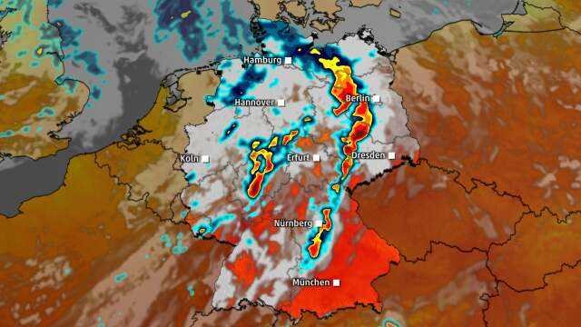
Until 7 p.m.: Hamburg could be lucky. The thunderstorms in the north are somewhat weaker. Schwerin and Magdeburg will have done the hardest by 7 p.m. The first storms are imminent in Berlin and Erfurt. There can still be supercells.
Storms are also threatening in the south in the evening. The first line of thunderstorms increases again in the evening from Erfurt to Ingolstadt. The second line of thunderstorms mainly covers North Rhine-Westphalia, Hesse and Thuringia.
Friday night: Highest alert level in the Berlin area
Till 21 o’clock: It’s getting tricky in the east: One can only hope that the worst thunderstorms don’t hit Berlin directly. Because until 9 p.m. there is the highest alert level around Berlin, from Greifswald to Cottbus and even in Dresden it could still be dangerous. Please seek shelter in the event of a thunderstorm. There is still a risk of tornadoes.
In Bavaria, especially in Franconia and the Upper Palatinate, heavy hail can also occur late in the evening. So please be careful in Nuremberg, Ingolstadt, Weiden and Regensburg and of course in between.
Until 11 p.m.: The storms move to Poland. From Karlsruhe to Nuremberg there is still lightning on the second line of thunderstorms, which can intensify again during the night, but the worst is already over by this time.
Until 3 o’clock: It’s still thundering and pouring in the south. Even on Saturday morning it can still rain.
Friday is an exceptionally strong storm and near a thunderstorm there is danger to life! Such a situation rarely occurs in Germany. Heed the warnings and seek shelter as thunderstorms approach.
Only Schleswig-Holstein is spared. Although it rains heavily there, strong thunderstorms are not to be expected.