
The winter sports season got off to a bad start. There was a lack of snow in the lower-lying ski areas over the holidays. The situation is now getting better on slopes over 1500 meters. But the danger of avalanches has increased.
Green Christmas: In Flims, like in many other ski destinations, there was no snow over the festive season. Now he shall come.
Lots of green, narrow white stripes – and sometimes even Pflotsch. This is how many ski areas presented themselves over the festive period. Even the World Cup races in Adelboden sent pictures of bare surfaces next to the artificially snowed slopes around the world. So far there has been snow mainly around 200o meters above sea level.
With the new week, there is now a little more white on the slopes. But the fact remains: It’s still too warm for the time of year, and soon the rain in the valleys will spoil the fun again. In a longer-term forecast, the SRF meteorologists assume that areas above 1500 meters will be particularly snow-sure in the next few weeks. It will always snow there.
After all: The next few days offer a small ray of hope. Those who want to stand on skis or sit on a sled will soon be able to target more destinations. It was already trickling down gently on Monday night – especially at higher altitudes in Valais. As the Snow and Avalanche Research Institute (SLF) recorded, isolated up to 40 centimeters of fresh snow fell. In the south of Valais there were between 20 and 30 centimeters in several areas.
The snow line drops briefly to around 600 meters
This trend will continue in the coming days and should ensure good slope conditions in many places at the weekend: especially in parts of the Glarner Alps, in central Switzerland, in the Bernese Oberland and, as usual, in the Valais mountains. However, less snow is still to be expected in Graubünden.
According to forecasts, the snowfall line will drop to around 600 meters on Tuesday night and only rise again to 1400 to 1600 meters the following evening. On Wednesday and Thursday it could be around 1000 meters again.
Fresh snow and wind increase the risk of avalanches
Nevertheless, the week in the ski areas is not going to be completely carefree: the new flakes fall on a weak old snow cover. And because the wind blows strongly in the mountains, the danger of avalanches increases at the same time.
Great avalanche danger in parts of Valais
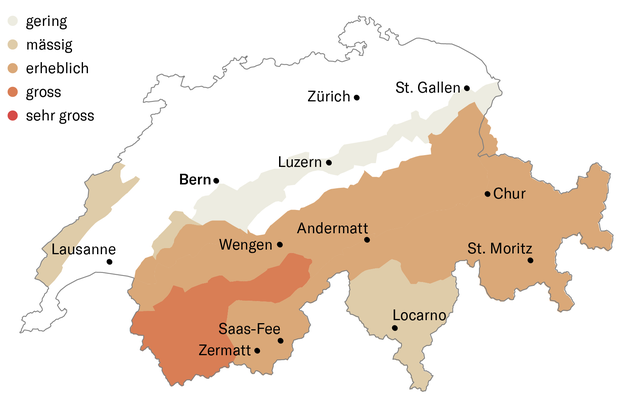
The SLF warned on Monday of a significant increase in this risk. In Valais, in the Bernese Oberland, in Central Switzerland and in Graubünden, the SLF described the risk of exposure over 2000 meters as “considerable” (level 3 of 5). In the most recent bulletin for Tuesday, the threat in parts of Valais rose to “large” (level 4). Spontaneous avalanches are to be expected at over 2200 meters, some very large ones, which could advance to medium altitudes. The conditions are critical for snow sports away from secured slopes.