Methane is one of the main greenhouse gases causing global warming. To identify leaks, Google uses satellite and artificial intelligence tools, in partnership with an environmental NGO.
It’s not just carbon dioxide (CO2): methane is one of the worst greenhouse gases. It is, at a minimum, responsible for a third of current global warming. So, in the fight against climate change and pollution, methane is a major issue – and we find leaks in many installations.
In this fight, Google and the NGO Environmental Defense Fund have formed a technological partnership. The multinational, which details the project in a post dated February 14, 2023, notably mobilizes its “Geo” centers, namely Google Maps and Street View. The objective is to identify the famous methane leaks and, above all, their exact source.
Google Maps of methane leaks
Usually, detecting methane leaks requires mobilizing aircraft and hand-held infrared cameras. It is difficult and expensive. For its part, Google’s “Geo” service can facilitate operations thanks to satellites and the processing of this satellite data.
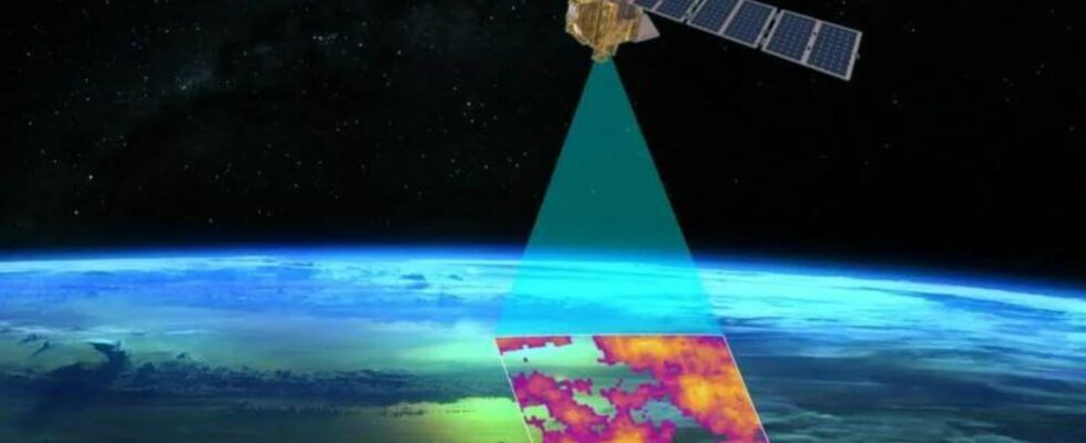
. // Source: Google")
“ We believe this information is extremely valuable for energy companies, researchers and the public sector to anticipate and mitigate methane emissions in components that are typically the most sensitive », Explained Yael Maguire – the vice president and general manager of sustainable development at Google Geo – to Business Insider.
To do this, a brand new satellite will be launched: MethaneSAT. At the cutting edge, its specificity will be able to detect both highly emitting sources and very small sources. This will be launched in early March 2024 via a SpaceX Falcon 9 rocket. An onboard algorithm will calculate the quantity of methane emitted in specific locations — then to monitor changes in emissions as well as the area covered by them.
A map is added to the project, for which Google mobilizes already proven internal artificial intelligence: that which maps trees, pedestrian crossings and intersections. The difference is that the AI, here, will have to detect information such as oil storage containers, in order to map gas and oil infrastructure. This information will be combined with that already known by the Environmental Defense Fund. Thus, by superimposing this mapping with MethaneSAT leak data, it will be possible to locate the origin of methane emissions and the extent of local pollution.
“ This information is extremely valuable for anticipating and mitigating emissions in oil and gas infrastructure which is typically most exposed to leaks “, estimates Google, before recalling that “ finding a solution to methane emissions is one of the biggest climate challenges we face today “. And indeed, information is a preliminary tool for action.
Subscribe for free to Artificielles, our newsletter on AI, designed by AIs, verified by Numerama!