
In the last few weeks, images of snow-free foothills of the Alps and ribbons of artificial snow next to green meadows have dominated the media. It was only really wintry in the high Alps. But now winter is returning to the middle elevations.
Legend:
The foothills of the Alps – here the Emmental – were already slightly “sweetened” on Monday afternoon.
Juerg Scheidegger
Already on Monday to 30 cm fresh snow
On Monday night, a cold front in the Alps caused a winter comeback. In the western Alps, 20 to 30 cm of snow fell, for example on the Great St. Bernhard in Valais.
Another 20 to locally 50 cm on the northern slope of the Alps
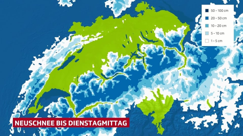
There will be more showers until Tuesday morning, the snow line gradually sinks to 600 to 400 m. With a strong north wind, the snow clouds accumulate on the northern flank of the Alps. From the Lower Valais via the Waadtländer, Bernese, Central Swiss and Eastern Swiss Alps to northern Grisons, another 20 to locally 50 cm of fresh snow will accumulate. In the rest of the Alps and in the foothills of the Alps, you can expect 5 to 20 cm.
Legend:
There is most fresh snow on the northern slope of the Alps.
SRF Weather
More snow and rain throughout the week
It will be dry on Tuesday afternoon, before a warm front will bring some snow and rain in places in the evening and on Wednesday night. From Wednesday to the weekend, further disruptions will follow daily, the snow line usually fluctuates in a range between 1000 and 1500 m. Above around 1500 m, another 20 to 60 cm of fresh snow are possible until the weekend, below it is sometimes snow, sometimes rain.
Beware of avalanche danger!
Lots of fresh snow and strong to stormy winds increase the risk of avalanches. The Institute for Snow and Avalanche Research SLF in Davos assesses the Avalanche danger constantly new.