The masses of cyclists show it: Day trips by bike to the bathing lake, in the mountains or in the beer garden are suddenly in great demand again, not least because of Corona. But how do you find the most beautiful and relaxing way to your destination?
In addition to helpful navigation apps that specialize entirely in cycling, such as Bikemap, Naviki or komoot, we can particularly recommend OpenCycleMap, which can be used to plan great bike tours across all regions of Europe. In addition to bicycle repair shops and parking lots, restaurants, cafés and bars can also be found along the route.
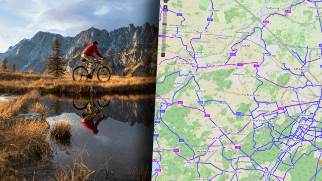
OpenCycleMap: Many colorful cycle paths through Germany
At first glance, the OpenCycleMap looks very colorful and confusing. But if you take a quick look at the legend of the OpenCycleMap, you will quickly find your way around. National cycle routes are marked in red, i.e. further routes that often lead from city to city. There are also regional cycle paths in purple, which, for example, connect larger towns within a region. The blue routes are mainly shorter inner-city routes – for example in Munich or Berlin.
Smaller cycle paths within towns and communities are also marked with blue dashed lines. These, in turn, can be easily distinguished from the pure footpaths, which are colored in orange. Nice feature by the way: Facilities such as fitness trails and other car-free streets are also entered in the OpenCycleMap.
Bicycle parking spaces, bike sharing and free drinking water
The bicycle parking spaces marked in blue rectangles are particularly practical, with fewer than 20 parking spaces, or with larger parking spaces with a “C” and the corresponding parking space capacity as a number. Rental stations for bike sharing, professional workshops and locations with freely accessible tools and free drinking water are also marked on the map.
There are also restaurants, cafes and bars, which are also noted on the map. Places with free WiFi are also highlighted accordingly. Particularly practical: if you have to drive out of the city into the surrounding area, for example, you can use the levels menu on the right edge of the screen to show public transport at the same time. In this way, you can find the right way to your destination right from the S-Bahn station.
Essential for bike tours: Possible climbs that need to be overcome. The layers offered in the upper right corner help here. Here you can call up a special landscape map that shows the respective altitude meters on the map.
As the name suggests, the OpenCycleMap is a freely accessible map service that anyone can edit and add additional information to. The associated large community enables a current status with the latest changes everywhere and comparatively quickly. The basis for the OpenCycleMap is OpenStreetMap, which is known from many navigation services and apps, which is also freely accessible and is kept up to date and constantly expanded by many volunteers.