
The melting of the ice is currently such that nearly 300 million people in the world risk being affected by the rise in water levels by 2050. Including hundreds of thousands in France, as reported by a recent study published in the Nature Communications magazine. That’s three times more than previous estimates.
According to a map developed by the Climate Central research institute, many metropolitan cities could be wiped off the map with the rising waters, which now seem inevitable.
Hauts-de-France
According to scientists, the north of France (Nord and Pas-de-Calais) would be the most affected region, with the submersion of the cities of Dunkirk, Grande-Synthe, Calais and Saint-Omer. A region where nearly 400,000 individuals live below sea level.
Other cities, such as Boulogne-sur-Mer, Berck, Le Touquet or even La Baie-de-Somme with the city of Crotoy would also be in danger, according to the latest estimates.
Screenshot – Climate Central
Normandy
Behind the Hauts-de-France, is Normandy where many cities also risk disappearing. The sea should, according to climatologists, rush into Dieppe and Fécamp. The city of Le Havre would also be strongly affected, especially in its southern part where the Seine would come out of its bed until reaching the cities of Château-Gaillard (Ain), passing through the city of Rouen.
On the Normandy coast, the cities of Deauville, Trouville, Cabourg, Ouistreham as well as part of Caen would also be affected by the rising waters.
The tourist sites of Mont-Saint-Michel and the regional natural park of the Marais du Cotentin et du Bessin will also be affected.
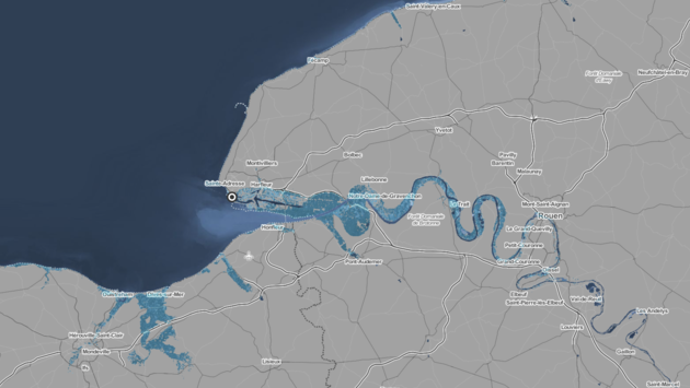
Screenshot – Climate Central
Brittany
The Brittany region will also not be left behind. Île-de-Bréhat, Paimpol and Saint-Malo could be three-quarters submerged, as could the towns of Landrellec and Trégastel.
The town of Île-Tudy, according to forecasts, would be completely submerged.
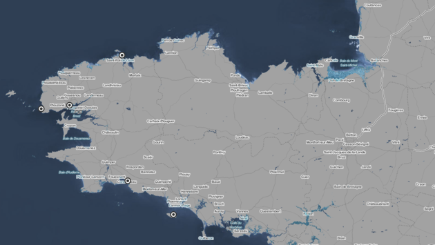
Screenshot – Climate Central
Loire Country
With the rising waters, the Pays-de-Loire region will not be spared because the ocean risks rushing into the Loire, flooding both the regional park of Brière but also the towns between Saint-Nazaire and Nantes.
The island of Noirmoutier would also be wiped off the map almost entirely.
And a large part of the Marais Poitevin Regional Natural Park will be under water.

Screenshot – Climate Central
Aquitaine
La Rochelle, Île-de-Ré and Oléron will, according to specialists, be partly submerged. Inland, the water would find a gateway to Rochefort as far as Cognac.
The Dordogne, just like the Seine in Normandy, would also come out of its bed to flood all the towns located on its banks, from Libourne to Sainte-Terre.
Bordeaux would end up underwater with the Garonne also coming out of its bed.
Just like the Adour river, whose water rushed in to submerge from Bayonne to Saint-Jean-de-Luz.
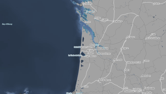
Screenshot – Climate Central
Mediterranean Basin
The Mediterranean region will also not be spared by the rising waters. According to the Institute, the Camargue will be submerged under water, until it reaches the city of Arles.
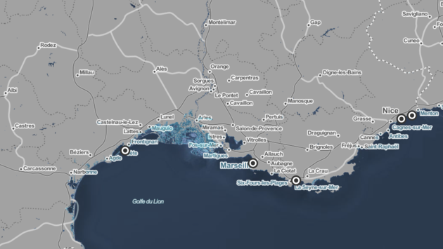
Screenshot – Climate Central
Rhine-Rhône watersheds
The watersheds of the Rhône and the Rhine, these areas where water is collected by a watercourse and its tributaries limited upstream by a watershed line, will be strongly affected by the rising waters. According to the model adopted by the Corvéa group (IPCC), these basins will be regularly affected by “slow floods and torrential floods”.

Screenshot – Climate Central
