“The worst is not over”: the prefect of Reunion Island Jacques Billant asked the inhabitants to be extra careful on Thursday because of the passage, north of its coasts, of cyclone Batsirai. The day should be marked by heavy rainfall, “so be careful when you live near waterways” warned the representative of the State, who evokes twelve minor injuries during the night.
The tropical cyclone ist’ right on our doorstep. It has been stationary for a few hours, we remain in the immediate periphery”with winds up to “150 km/h in the heights”said Emmanuel Cloppet, regional director of Météo France, during a press briefing at midday, local time.
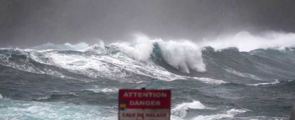
“We are in the most impactful period, in terms of swell and wind” , added the prefect of the island, warning the 860,000 inhabitants of the risk of flooding. It is “often at the back of the cyclone than the cloud bands”can have the greatest impact.
This continuous precipitation is expected to continue “at least all day and certainly the night to come” , according to Mr. Cloppet. Seven rivers are therefore on yellow alert and residents living in risk areas can take shelter in one of the 143 accommodation centers made available by the municipalities. “A little less than 200 people”had for the time being chosen to take refuge there, according to the prefecture.
Preventive water cuts to preserve the facilities affected 30,000 people in the morning, out of the 860,000 inhabitants of this Indian Ocean island, and disruptions to the electricity network affected all the municipalities of the territories. . Power cuts affected up to 61,000 homes, “thanks to the mobilization of EDF teams, 25,000 customers were able to be supplied via remote manoeuvres”corn “36,000 customers currently remain without electricity”said the prefect.
One meter of water in the Piton de la Fournaise region
The island was placed on hurricane red alert on Wednesday at 7 p.m. local time (3 p.m. GMT), requiring the 860,000 inhabitants to barricade themselves. No landslides or inundation or flooding of rivers have been reported at this stage. The strongest winds recorded on the island, on the heights, were measured between 130 and 150 km/h. On the other hand, winds blew at an average of 185 km / h at sea with maximum gusts at 260 km / h.
Météo France confirmed in the early morning that the trajectory of Batsirai had been maintained and that it should pass as close as possible, 180 km from the coast of this French overseas department. As it slowed its course, it will happen later than initially expected, meteorologists said without stating a new forecast other than “during the morning”.
Rains have been falling since midday on Wednesday with the most significant accumulations in the heights of the south of the island. In 24 hours, a meter of water fell on the uninhabited region of Piton de la Fournaise, underlined Météo France Thursday morning. Conditions will only improve if “end of the day Thursday and especially during the day Friday”.
The island regularly sees tropical cyclones like Dumazile pass off its coast, which caused flooding and flooding in 2018, but the last devastating cyclone, Gamède, killed two people and caused extensive damage in 2007.
The red alert is the third degree in the scale of hurricane alerts which has four. The population is invited to confine themselves and only the emergency services can circulate.
Update at 12:30 p.m. with the new location of the cyclone and press conference by Météo France.