Google Maps knows every point on earth. But if you want to know the altitude, you need the following trick to display the altitude in Google Maps. Extra tip: You can also display the altitude difference on a map without Google Maps.
Enlarge
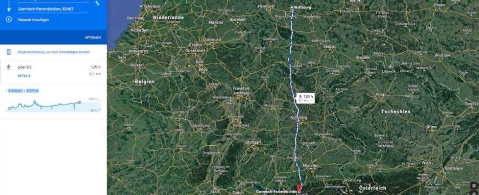
For routes by bike, Google also provides an elevation profile of the route. In this case, you have to negotiate 6,416 meters of altitude uphill and at least 5,771 meters of altitude to go downhill.
Anyone who uses Google Maps for route planning has been able to have an elevation profile output for their route since mid-2014. Google originally only displayed this altitude profile with the altitude meters if you selected the bicycle as the means of transport. For some years now, the elevation profile has also been available for pedestrians, for example for hiking. The elevation profile does not appear for any other means of transport (car, train, plane). If the elevation profile does not appear even when the mode of transport is bicycle or on foot, then there are no significant differences in elevation to be overcome on the calculated route.
This is how you show the elevation profile
On the desktop PC or notebook:
Set the starting point and destination of a route on Google Maps. Then click on the bicycle or pedestrian icon. You can already see the altitude profile with the altitude meters to the left of the map and above the route description. Including information on how many meters in altitude you have to pedal up and how many meters in altitude it is easy to descend again.

Enlarge
The same route with uphill and downhill slopes in the map view.
In the iOS or Android app:
You make your selection as above, except that you then swipe up from the bottom of the screen to see the elevation profile.
How to determine the height of a certain point
You can find out how high a certain point is on your route or generally on the map by taking a detour. If you are already on https://maps.google.de, you can right-click on the item you are looking for and select “What’s here?” (Second menu item from the top). Google will then show you information about the position including the latitude and longitude. Click on the little info box now displayed for this point. Now Google Maps shows you this location centrally. The coordinates for latitude and longitude can be found on the left-hand side of the screen.

Enlarge
Copy the values outlined by us.
Just copy that
shown small
Values with Ctrl + C. Then paste these values into the upper input field on the www.mapcoordinates.net page and press the Enter key. You can already see on the map where the position you are looking for is and how many meters above sea level it is.

Enlarge
The right-click in the “What’s Here?” We have entered the latitude and longitude determined on mapcoordinates.net.
Alternatively, you can also start directly at www.mapcoordinates.net and search for the desired location by name in the input field. The entry of place names works of course only with named places, for any point on the map far away from a place click on the map with the left mouse button instead. Then the page shows you the latitude, longitude and altitude.

Enlarge
You can also enter the place name directly on mapcoordinates.net and the latitude and longitude will then be displayed. Of course, this only works for points on the map for which there is a place name.
Google Maps for iOS & Android: Measure distance very easily
Google Maps in the test: free navigation with exact traffic situation information