Heavy fighting in Ukraine
Where the Ukrainian offensive is advancing
By Martin Morcinek
7/11/2023 5:19 p.m
The large-scale attack by the Ukrainians has been going on for a good five weeks, and the hoped-for breakthrough has not materialized so far. However, in the battles along the approximately 1,000-kilometer-long front line, several thrusts can be identified. A look at the map shows the most important focal points.
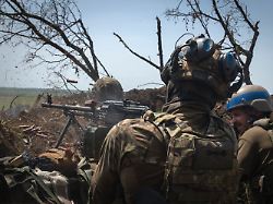
In the fight against the invading Russian army, Ukraine is slowly making visible progress. At several sections of the front are located the Ukrainian armed forces on the advance. The initial euphoria, however, has given way to disillusionment after the first phase of the counter-offensive: the fighting is extremely tough, every meter of ground has to be wrested from the occupiers in bloody battles. The hoped-for quick breakthrough through the Russian lines is still pending.
However, a comparison of the current situation map with the status of early June shows that the front line has started to move in at least four places a good five weeks after the start of the Ukrainian counteroffensive. Ukrainian advances are particularly evident on the Zaporizhia front in the south and near Bakhmut in the east of the country.
According to reports from Ukrainian and Russian sources, there is intense fighting east of the Kakhovka reservoir near Pyatychatky, south of Orikhiv on the Tokmak front and south of Welyka Novosilka in the east of the Zaporizhia region. In this context, military experts speak of advances or “axes of attack” in the direction of the southern Ukrainian cities of Melitopol and Tokmak (Pyatychatky advance), in the direction of Berdyansk (Orichiv advance) and in the direction of Mariupol (advance near Welyka Nowosilka).
All three advances in the Zaporizhia region are in the so-called central area of the front between the Kakhovka reservoir and the Donbass. A Ukrainian breakthrough here would have severe consequences for the Russian occupying army: the Russian-controlled land bridge to the Crimea runs in a corridor about 100 kilometers wide in this area south of the combat zone. The further south the Ukrainians advance, the narrower it becomes for the supply routes of the Russian troops.
At Pyatychatky near the drained Kachowka reservoir, the Ukrainian attack seems to have gotten stuck in front of the front line of defense of the Russian position system. However, the fighting there is tying up extensive Russian forces: Putin’s military planners cannot afford to retreat tactically here.
After a few kilometers southwest of Pyatychatky begins the wide plain of the southern Ukrainian steppe. The comparatively sparsely populated agricultural region gives an advancing army largely free rein. Down to the Crimea there are hardly any natural terrain obstacles between the left bank of the Dnipro and Melitopol and only a few places that are suitable for effective defense.
The Orikhiv advance is just under 30 kilometers to the east: at this point on the front, Ukrainian units apparently managed to break through the Russian barrage and minefields to the first Russian line of defense. There has been fighting here for several days, including around the village of Roboytne. During the first major battles north of this town in June, among other things, the first Ukrainian Leopard 2 tanks were lost. In early July, Russian military bloggers reported that Ukrainian spearheads had broken into the Russian trench systems there.
So far, however, the Ukrainians have achieved the greatest gains in territory of the current offensive 80 kilometers to the east at Welyka Nowosilka. There, in the extreme south-west of the Donetsk region, the Ukrainian armed forces were able to liberate more than half a dozen towns as early as June. Place names like Neskuchne, Storoschewe, Blahodatne or Riwnopil stand for hard-won Ukrainian successes. The battles there follow the river valleys of the Mokri Jaly, which flows here coming from Wolnowacha in a northerly direction.
A possible target for the Ukrainian advance near Welyka Nowosilka would be Mariupol: the Ukrainian port city is around 100 kilometers south on the shore of the Azov Sea. Mariupol has enormous symbolic meaning for both sides: Last spring, the Russian invading army was only able to conquer the metropolis, which once had around 450,000 inhabitants, after weeks of siege and brutal bombing.
Russian propaganda otherwise only attributes a similar symbolic value to Bakhmut. There, far in the east of Ukraine, the Russian troops are also under massive pressure. In the past few weeks, Ukrainian associations have been able to advance towards the city area at several points. The Ukrainians are systematically digging out one Russian position after the other. Even a threatening encirclement no longer seems impossible.
The exact course of the front can only be determined indirectly in the fog of war and propaganda. The information used here is based on publicly available information, the content of which is checked step by step for plausibility and traceability. The most important source of information are official announcements from Kiev. In addition, there are assessments by Western experts and the abundance of published video material, from which some detailed conclusions can be drawn about the situation at the front.
Information from Russian sources, on the other hand, is largely unreliable. Unsubstantiated claims are lined up here with obvious lies. Multiple repetitions are obviously aimed at stoking uncertainties and blurring actual developments. In individual cases, however, information from the Russian side can provide additional information, for example if the shelling of a previously Russian-controlled town is reported or the extent of Ukrainian advances is mentioned.
The most important support for assessing the current course of the front are satellite photos. The shots from space can sometimes provide an independent perspective on what is happening on the ground. Under ideal conditions and with a cloudless sky in the combat zone, suitable comparison images can be used to identify vehicle tracks, shell holes and newly erected positions. In sum, these indications condense into an overall picture from a distance: As a result, the drawn front line approaches what is happening on the ground with a certain delay. The public gets an approximate picture of the course of the front in Ukraine.