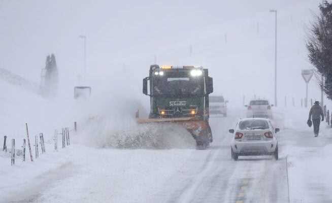
After a break of several weeks, winter is returning in Switzerland. Around 40 centimeters of fresh snow fell in the mountains on Tuesday night. Up to one and a half meters are expected by Thursday.
A lot of snow is also falling in Central Switzerland: clearing work on Tuesday near Einsiedeln.
tsf. In Switzerland, stormy north-westerly high-altitude currents are currently bringing a lot of humid polar air. There has been a temporary break from snow or sleet – at least in the Mittelland – since Tuesday afternoon. More rain is likely to set in towards evening. Heavy snowfall is expected, especially in the mountains.
First significant snow event in 2022: By Tuesday morning, 25 to 50 cm of fresh snow fell on the central/eastern northern slope of the Alps and in northern/eastern Grisons. Another 50 to 80 cm can be expected by Wednesday evening: https://t.co/HQKjtzyxjY. Fresh snow on 1.2. at 6 UTC: pic.twitter.com/JYyPaZ1jVP
— MeteoSwiss (@meteoSwiss) February 1, 2022
As early as Tuesday night, around 40 centimeters of fresh snow were measured in the mountains. From Tuesday evening it should snow at least another 20 centimeters. There was most fresh snow on Tuesday on the Weissfluhjoch near Davos with 65 centimeters. In Arosa it was still 51 centimeters. In the higher areas of the Glarnerland, the amount of fresh snow was 40 centimeters.
There is most snow in eastern and central Switzerland
There is currently the most snow on the Weissfluhjoch (158 centimetres), in Ulrichen in the Upper Valais (100 centimetres), in Arosa (99 centimetres), in Bivio (82 centimetres), in Andermatt (78 centimetres) and in Davos (also 78 centimetres).
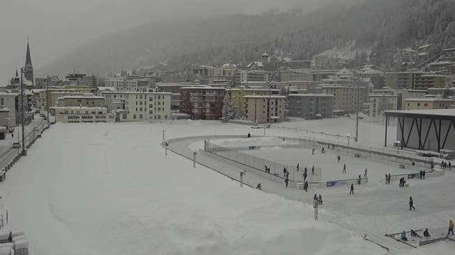
Almost 30 centimeters of snow fell in Davos on Tuesday night.
The same style continues on Wednesday: snow and rain in the Mittelland, lots of snow in the Alps. According to a forecast by Meteonews, up to 70 centimeters of fresh snow are expected on the eastern northern slope of the Alps and in eastern Grisons.
In higher regions, the snowfall is likely to continue until Thursday morning. Then there could be up to one and a half meters of fresh snow in the Central Alps.
Until today 4 o’clock arrived in the #mountains already 20 to 40cm in places #fresh snow together. During the day they let #rainfall after before it towards evening with one #warm front again #wet will. Warnings: https://t.co/hfVLJlv5iY Forecasts: https://t.co/ZAjlNf1mb3 (gz) pic.twitter.com/pLmICyo3pM
— MeteoNews Switzerland (@MeteoNewsAG) February 1, 2022
The Meteonews map shows the maximum amount of fresh snowfall from the Bernese Oberland through the Urnerland to the Glarnerland. In the lowlands, on the other hand, there is little snow, here it rains from Wednesday night.
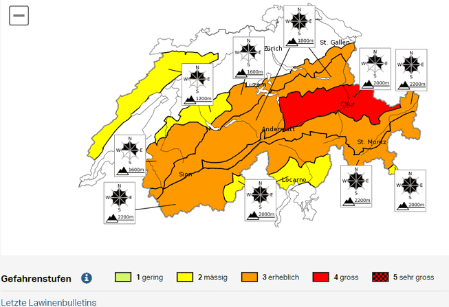
Partly large avalanche danger
Due to the strong winds, large amounts of snow have to be transported in the mountains. The Swiss Avalanche Research Institute therefore raised the avalanche danger along the Alps to level 3 (“considerable”) or even 4 (“great danger”) out of 5 possible levels on Tuesday. The danger could only ease slightly from Thursday.
Public transport partially interrupted
The snowfall and wind speeds of up to 160 kilometers per hour also affect public transport. There are currently three disruptions due to the weather. According to the SBB, all trains in Innerrhoden between Weissbad and Wasserauen have been canceled from 4 a.m. to 7 p.m. Tuesday due to the storm. Due to strong winds, the cable car between Unterterzen and Flumserberg-Tannenboden has also been suspended for an indefinite period.
Due to the stormy weather, railway operations are also partially restricted in the ski areas.