New war zone in Ukraine?
That’s how quickly the Kachowka reservoir dries up
By Martin Morcinek
06/21/2023, 1:35 p.m
Two weeks after the dam burst in Ukraine, satellites recorded dramatic changes on the ground: the water from the Kakhovka reservoir has largely disappeared. In the middle of the war zone, not only huge uncovered areas become visible.
In southern Ukraine, new land is emerging on the site of the former Kachowka reservoir: Current images from the European earth observation satellite Sentinel-2 now show further extensive, dry areas. Where the largest inland body of water in Ukraine used to cover a 200-kilometer section of the front line, new terrain appeared within a few days.
Two weeks after the dam burst, most of the accumulated water has disappeared. The remaining course of the Dnipro flows through the newly created area with numerous meanders. In between are muddy swamp zones, buried oxbow lakes and the old river bed that was under water for almost seven decades.
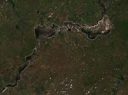
In a direct comparison of the before and after pictures, the dramatic changes at the Kachowka reservoir can be clearly seen. The photo on the left shows the region in a picture taken on June 5, 2023. You can see the situation on the day before the catastrophic dam burst.
The dam itself can only be seen from this height if you look closely next to the town of Nowa Kachowka in the lower left corner. The dam stretches from north-west to south-east across the river valley, which is a good 2.4 kilometers wide here. In the days after the dam burst on June 6, wide banks of mud and gravel rose from the outflowing floodwaters in front of the structure.
The picture on the right was taken on June 20th, two weeks after the destruction of the dam walls. The Zaporizhia nuclear power plant, cut off from the fresh water supply, is located in the upper half of these images, just to the right of the center. The cooling pond of the power plant, which is around three and a half kilometers wide, is easy to find in both pictures thanks to its characteristic ring structure.
In the north-east, at the upper end of the reservoir area, the Dnipro flows close to the right bank. All that remains of the lake’s water surface is a network of seeping streams and ponds covering an area of around 400 square kilometers. On the left bank, i.e. on the south-eastern side near Kamianske (map), a wide strip of bank has developed. In this area, the reservoir, as a natural terrain obstacle, formed the western boundary of the combat zone along the Zaporizhia front.
Further downstream at Babyne (Map) the Dnipro turns south. The reservoir narrowed significantly here from a width of ten to 15 kilometers: From there to Nowa Kachowka, the two banks are only a good four kilometers apart. After the dam burst, however, wide sandbanks formed here as well. In several places, free Ukraine appears to be separated from Russian-occupied territory only by a 300-meter-wide stretch of open water.
Devastating dam break consequences
It is still unclear exactly how the conditions on the ground are. Will the bottom of the lake be navigable soon? Or can the Dnipro be crossed below the bend at Babyne with a pontoon bridge? A lot depends on the answers to these questions for both sides: From a military point of view, the empty reservoir could quickly develop into an open flank.
In summer weather conditions, it is said, the layers of sediment at the bottom of the reservoir could solidify. However, the satellite images from the first few days after the dam burst show other changes that are no less dramatic: Within two weeks, the vegetation south of the reservoir, which can be seen from space, has already changed massively.
Large areas now appear dark brown. The obvious reason: intensive irrigation farming has been practiced in the region for decades. Due to the bursting of the dam, all the larger canals have dried up. The water supply has been cut off and the extensive areas under cultivation in the south of Ukraine are drying up.