Imaging company Maxar Technologies released satellite images taken over the Ukrainian coastal city on Saturday. These reveal significant destruction in residential areas and in the city’s pediatric hospital.
Mariupol, city besieged and subjected to a deluge of fire. For nearly two weeks, the coastal city in southern Ukraine – and the 360,000 residents believed to still be trapped there – have been the target of intense Russian strikes, ripping through buildings in the city center as well as areas residential. On the first day of the attack, March 1, a missile fell on a central district, killing a 16-year-old boy. The next day, a maternity ward and a school are pounded. The most emblematic destruction is that of the city’s pediatric hospital, pounded by the Russian army on March 9.
This weekend, the specialist company Maxar delivered satellite images that allow a better assessment of the extent of the damage to Mariupol. The American company, which had already made it possible to document the imposing Russian military convoy en route to Kyiv, reveals striking shots in the form of before and after. What to measure a little more still the company of devastation in progress in the city.
The devastated children’s hospital
The first shot shows Mariupol Number 3 Hospital, which houses several pediatric wards, before and after suffering strikes from the Russian army on March 9. The red-roofed building, to the right of the two images, houses the hospital’s children’s outpatient clinic. In the building bars located in the center, there are other pediatric services, for example in ophthalmology. One of these buildings also normally houses an obstetrics department. Finally, the building located at the very bottom of the image usually houses an oncology department. All these buildings were visibly badly damaged.
The day after the bombing, on Thursday March 10, the town hall of Mariupol announced that three people had died at the scene, including a child. “Total staging for the purpose of provocation in order to maintain the anti-Russian agitation of the Western public”, by “nationalists” Ukrainians, responds the spokesman for the Ministry of Defense, Igor Konashenkov. The satellite images remain eloquent.
Buildings blackened by strikes
The second shot was taken at the same location, west of Mariupol, at the corner of Mytropolytska and Kuprina streets. The first snapshot was taken in June 2021, months before the start of the Russian invasion, the second date from Saturday March 12. The contrast between the two images is impressive. At the top of the image, from left to right, were a logistics warehouse, a supermarket and a DIY store specializing in plumbing products. They all seem to have suffered strikes. But it is at the bottom of the image that the destruction is most impressive: a set of residential buildings is blackened by the bombardments, while few surrounding trees seem to still be standing.
:quality(70)/cloudfront-eu-central-1.images.arcpublishing.com/liberation/6OS7KVZ5N5AJ3JI2LDN7C4R77M.jpg)
The neighborhood was obviously a combat zone. A clue is visible on the artery that starts from the bottom of the image – Mytropolytska Street: the axis seems blocked by an aggregate of heavy goods vehicles, forming a barricade. A method that we have seen used in other cities in Ukraine, for example in Enerhodar to block access to the Zaporizhia nuclear power plant.
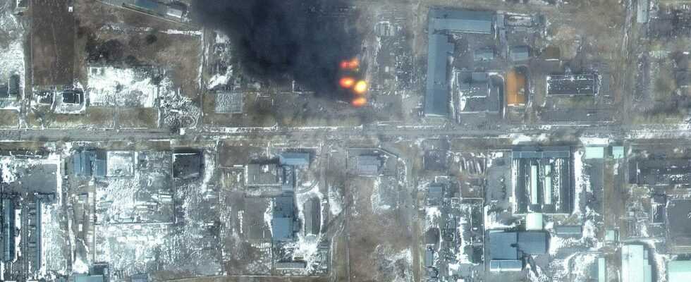
A still smoking building
The third shot is taken a little further south of Mytropolytska Street, at the corner with Zelinskoho Street which crosses the bottom of the image. It is a mixed residential area, mixing pavilions and buildings, the latter arranged around a park with sports fields. An image of apparent tranquility in the photo on the left, taken in June 2021, of which there is not much left on the shot on the right, taken on Saturday March 12.
:quality(70)/cloudfront-eu-central-1.images.arcpublishing.com/liberation/LKSYMDY2DNGTTKOKUE5YNOC45E.jpg)
One of the buildings in the neighborhood is still smoking after being hit by a strike. Beside him, a car dealership, which is on the corner of the two streets, seems to have been ravaged by gunfire. Buildings along Mytropolytska Street towards the top of the image also show signs of destruction. Finally, no more cars circulate in the streets. The war has suspended life.