A “Task Force” made up of experts from several American agencies warns in a new report that the sea level should rise drastically by 2030: as much as in a century of measurements! This should notably result in significant flooding during high tides and storms.
The American coast is not uniformly concerned.
Uptrend
Periodically, the large American government Task Force on the level of the oceans meets to compare the current figures, but also the simulations and estimates of the various experts and climatologists. It brings together NASA, NOAA, USGS as well as some specialists from other branches of government and issues reports, in particular for future projections up to 2150 (depending on various scenarios).
This document has a particular focus on the next 30 years, and for certain American coastal cities, it sounds the alarm: scientists and simulations predict an average rise of 25 to 30 cm in sea level on the coasts of the United States, in its “moderate” scenario. That’s as much in 30 years as in a century of measurements and increases.
The pace is accelerating compared to previous studies, and the Task Force justifies this by better understanding and better measurements of climate change (by satellites, among others), in particular with regard to the impact of wind profiles and currents.
The finger on the coastline
The work provided the basis for this site, which makes it possible to estimate at various key points the future rises in mean level along the coasts. Because, contrary to what intuition tells us, the sea level is not uniform along the entire coastline. It indeed depends on the winds and currents… not to mention the perception of the level, which depends on the effects of the tide, but also and above all on the measures put in place to preserve the coasts (development of the land, dykes, reconstitution of dunes, etc.) .
The east coast would therefore be unsurprisingly the most affected depending on currents and winds by 2050, with 39 cm rise in New York, 33 cm on the Florida coast and more than 45 cm rise south of Louisiana . In Los Angeles, major beaches will face a 22 cm rise in the level of the Pacific.
Above all, the report insists on one point: it will not be a constant increase, but there will be many more effects during high tides and storms. This also works “against” the figures and projections: this increase will not give the impression of being dramatic, except during extreme events, the severity and frequency of which will be reinforced.
Bring boots…
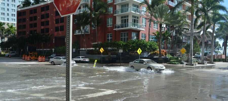
For many observers, this report is only further confirmation, and there are already several regions in the United States where taxpayers are splitting tens of millions of dollars in an attempt to stem the rise and preserve their landscape. coastal. With an average rise of around 30 cm, some mega-cities will nevertheless need much more ambitious means. This is the case of Miami, whose center and suburbs are already at sea level today, or New York, whose basements are systematically flooded in the event of a storm.
Finally, we can point out that if this study is centered on the United States, the rise in the level of the oceans will also affect our French coasts by 2050. The IPCC projects a global rise of 28 cm in its last report on the oceans at horizon 2100, but this is the most favorable scenario. Indeed, the current trajectory estimates that it will rather be between 63 cm and 1 m. The website Climate Central has also recently put an interactive map in place to better represent things.
Source:
NASA
13