The crossing of the Alps on the E5 long-distance hiking trail from Oberstdorf to Merano is becoming increasingly popular. But there is also a lesser known alternative route. Away from crowded mountain huts, FOCUS online author Ludwig Obermeier has experienced lonely mountain peaks, impressive views and unforgettable moments.
- Note: The crossing of the Alps along the E5 took place in summer 2018
We were already in the pouring rain for a good three hours when the mood in our group sank to zero. I am already frustrated with the sow weather. Shortly before we reach the Erlanger Hütte, the goal of our fourth day's stage, we still have to overcome a 2600 meter high mountain saddle. So far actually no problem.
If it weren't for the narrow path, the slippery ground and extremely steep terrain. The climb there becomes a strenuous and wet adventure. Peter, our oldest companion, curses almost continuously on this day, but I just ignore him. Standing still and moaning doesn't help us, I think in silence.
But the feeling that you made it quickly made you forget the exertion in the end. Once at the top of the 2600 meter high saddle, at around six degrees we finally see the Wettersee and the Erlanger Hütte in Tyrol. After a short and no less delicate descent through several snow fields that lie directly on the steep bank of the lake, we finally reach our destination on day four. Well done again.
It is relieving moments like this that are remembered by crossing the Alps along the E5 long-distance hiking trail – but not only. Also breathtaking views, lonely nature and unpredictable weather.
Rain showers and rumblings of thunder: Day 1 of crossing the Alps begins uncomfortably
We are not initially spoiled with sun when we start our first day's stage in Oberstdorf across the Oytal and Himmeleck towards the Prinz-Luitpold-Haus. Already in the morning the first heavy rain shower with thunder rumbles catches us – luckily at the time when the next hut is only a good 15 minutes away. After a two-hour break and a beer, we then head towards the Prinz-Luitpold-Haus. Always accompanied by chamois, marmots and the hope that it stays dry.
Even if the Allgäu does not show itself from the sunny side that day. The sight of the lush green mountain slopes is still overwhelmingly beautiful, on which the rain clouds hang along like climbers in the rock. In the evening our group – consisting of seven people and a dog – arrives at the Prinz-Luitpold-Haus. The next big goal for day two, the almost 2600 meter high Hochvogel, is already in sight again. But before that, I fall into bed tired.
Unsightly discovery on a majestic mountain
The second day starts early. We will soon reach the first snow fields and the terrain will become increasingly rocky and steep. The anticipation for the summit is evident.
And that has it's reason.
There are mountains that blow a very special myth. These include the Hochvogel, one of the most striking mountains in the Allgäu. But as we will soon see on this day, it threatens to lose its striking appearance. Because the already very jagged massif breaks apart. The primordial forces gnaw at the Hochvogel so much that the southern flank of the mountain on Austrian territory threatens to fall. Because of this, the Bäumenheimer Weg has been closed to hikers for life-threatening reasons since September 2014. The Hochvogel can only be climbed via the German side and the Prinz-Luitpold-Haus or the Fuchsensattel on the Tyrolean side.
Exciting but no time right now?
The Hochvogel has become a patient
And something else strikes us on this day: At the summit itself, many orange balls are anchored in the rock. The geological processes at the summit of the 2592 meter high mountain have been monitored by scientists for some time. The Hochvogel has become a patient.
"Movement measurements by the Technical University of Munich in the summit area have shown that the large gap widens by several centimeters within a few months," says the website of the Alpine Club section Donauwörth, which took care of blocking the Bäumenheimer Weg.
With a thoughtful but satisfied feeling that we have climbed the mountain, we head for the valley town of Hinterhornbach via the so-called Kalten Winkel and a snow field that is up to 45 degrees steep. A little slide included. The small village at around 1100 meters is our goal for the second stage. At Gasthof Alpenrose, we let ourselves go well at the end of the long second stage.
Crossing the Alps: From Lech- we continue to the Pitztal
The next two days we take a more relaxed approach. First we take a shuttle from Hinterhornbach to Pfaflar, the oldest settlement in Austria. From here we hike over the Hahntennjoch and the Scharnitzsattel towards Muttenkopfhütte. An easy hike that requires some climbing skills just before the Scharnitz saddle – which turned out to be somewhat problematic, at least for the bitch. "Jackie" did it together.
In the afternoon from day three there is a taxi transfer again. From Imst, take a taxi up to the Ludwigsburger hut above the Pitztal valley – and all this with pouring rain. Even the last motivated among us cried no more tears for the missed climb. The sky over Tyrol wept all the more.
In fairly modest weather conditions, we went from Ludwigsburg to Erlanger Hütte on day four (both huts were almost empty on these days and a dream). The shortest day's stage between the two rustic huts only lasted around three and a half hours – all garnished with constant rain.
Sauder weather on the shortest stage to the Erlanger hut
The rain drama mentioned could take its course. First cloudy and dry, then drizzle, then more and more rain. When we finally reached the 2550 meter high Erlanger hut after around three and a half hours, everyone was probably wondering what we were actually doing here. But that's how it is with crossing the Alps: If you don't want to get wet, you'd better go to the Mediterranean or have rainproof equipment with you.
Crossing the Alps off the E5
Day 1: Oberstdorf – Prince Luitpold House
Day 2: Prinz-Luitpold-Haus – Hinterhornbach
Day 3: Pfaflar – Ludwigsburger Hütte (with transfer)
Day 4: Ludwigsburger Hütte – Erlanger Hütte
Day 5: Erlanger Hütte – Umhausen – Tiefenbachferner – Vent (with transfer from Umhausen to Sölden)
Day 6: Vent – Bella Vista
Day 7: Bella Vista – Gnawed
Day 8: Bus transfer back to Oberstdorf
Distance: around 120 kilometers
Accommodation: dogs are allowed in all huts
The next morning the path led us down to Umhausen in the Ötztal. Alpine roses, a waterfall and a few more clouds accompanied us on the descent. By this morning the bad weather should be over for the rest of the week. At last!
From Umhausen we went by bus to Sölden and from there by bus to Tiefenbachferner. We meandered more and more towards the climax of our tour over dozen curves: The glaciers around Sölden impressed me through the bus window. How must it be to see them up close? That experience was yet to come.
A real pearl on the E5! The panorama trail from Tiefenbachferner to Vent
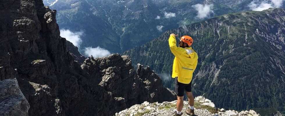
On this day, however, the first step is from the Tiefenbachferner's parking lot via the beautiful and easy-to-walk panoramic mountain trail to Vent – and finally in the sun! The eleven kilometer long hiking trail offers incredible views of steep mountain slopes and the 3000 m ahead. Vent itself is a small village at 1900 meters above sea level in the rear Ötztal, which enjoys an excellent reputation among mountaineers due to well-known mountains such as the Wildspitze and the Similaun.
So we were ready for the grand finale. But before that was a goodbye.
Bitch "Jackie" said after day five together with her owner "Servus". The old dog lady had mastered the crossing of the Alps with flying colors, but the stages had not left her without a trace. In general, crossing the Alps with a dog is feasible. There are enough huts to accommodate dogs, and difficult and steep routes can usually be avoided. Nevertheless, dog owners should keep in mind that such a hike can also be very demanding for the four-legged friends.
Day six promised to be a real highlight. From Vent we made our way through the Rofental to our highest accommodation on the entire hike. The goal: The Bella Vista refuge at an altitude of around 2800 meters. The way: fantastic and varied.
Glacier experience in the back ice
First, through colorful mountain meadows and the Hochjoch hospice, we continue to work our way into a barren high mountain landscape. Soon it feels like you can touch the sky with your index finger. When we reach the Bella Vista hut in Italy, a very exclusive (four-course dinner, panoramic showers and sauna) and well-run hut, happiness is perfect – and wheat beer is a blessing. If you want, you can – like our group – climb the summit Im Hinteren Eis at 3270 meters from the refuge. Nimble climbers can reach the summit in just over an hour from the hut. From there there is an impressive view of the Hintereisferner, one of the largest glaciers in Tyrol.
Our last day of hiking finally took us from the Bella Vista hut down around 1200 meters to the Schnalstal valley. After all the impressions we spontaneously took the 3251 meter high Grawand with us and climbed down from there via a via ferrata to Vernagt. South Tyrol showed its sunny side at the end of an unforgettable tour. Blue skies framed green mountain meadows, rushing streams and the turquoise sparkling reservoir in the valley.
We had arrived. In South Tyrol, in paradise, at our destination.
Information about crossing the Alps along the E5
- Duration: usually eight days (shorter if transfer is used)
- Distance: around 120 kilometers run
- Elevation gain: adds up to around 19,000 elevation gain
- Packing list: There is a detailed list here
- Helpful apps for tracking: Outdoor Active of the Alpine Club, Komoot, Runtastic