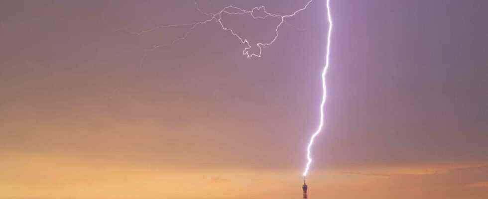
Strong thunderstorms broke out overnight from Sunday to Monday on an axis going from the Paris basin to the Yonne and as far as the Ardennes, accompanied by intense rains, heavy hailstorms and sometimes strong gusts. In Paris, lightning struck the Eiffel Tower late in the evening. Hundreds of impacts have been recorded above the Ile-de-France sky. A few Parisians opened their windows despite the pouring rain in order to immortalize the stormy cell.
A furtive storm this evening in Paris, which symbolically announces… (wrong answers only) #thunderstorms #legislativeelections2022 pic.twitter.com/Goaq4UHuJM
— ffaabb (@_ffaabb) June 19, 2022
#Paris #thunderstorm #opera pic.twitter.com/WAusRtHdFE
— George (@gmrmlb) June 19, 2022
In addition, hailstones of 4 to 5 centimeters were observed in particular in Loiret and Seine-et-Marne. Very intense rainfall accumulations were recorded: 47 mm in 1 hour including 30 mm in less than 15 minutes in Vierzon, 60 mm in 30 minutes including 40 mm in 15 minutes in Lorris (Loiret).
To read : Peaks at 42°/43°C in Aquitaine, absolute record in Biarritz
In the evening, a new marked stormy degradation will be set up by the South-West. The storms will organize mainly on a South-West / North-East axis, strengthening during the evening of Monday and the night of Monday to Tuesday, shifting towards the north of the region. These storms may be accompanied by violent phenomena (of the same order of magnitude as Sunday’s storms, or even more locally). The very high temperatures of the past few days are easing, except in Lyonnais.