By SudOuest.fr with AFP
Sunday will be very rainy in the South-West, especially in the Pyrenees and the Landes where there is a high risk of flooding. Météo France does not expect a lull before Tuesday
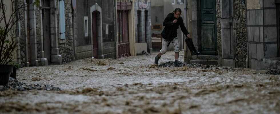
Heavy rains hit the country this Sunday, January 9. The Pyrénées-Atlantiques and the Landes, where very significant amounts of precipitation are expected on Sunday evening, were, like the Hautes Pyrénées, Ariège and Haute-Garonne, placed on red flood alert, Météo France announced on Sunday. .
This Sunday evening, the prefecture advised against the inhabitants of the Aspe and Ossau valleys to drive their children to school this Monday, January 10 in the morning. Schools will provide a minimum reception service for pupils.
The Gave d’Oloron, which flows from the Pyrenees in the two departments, was placed in red vigilance and could experience “very significant overflows” from Monday morning, said Vigicrues in his last bulletin.
Friday evening, the prefecture of Pyrénées-Atlantiques had already issued a prevention message and called for vigilance.
This rain-snow episode, which persisted on Sunday in the Pyrenean departments, will initially be weak to moderate (rainfall intensities between 2 and 5 mm / hour), with a rain-snow limit at around 1200 / 1300m. altitude.
Then, the rains will become more sustained Sunday evening and the night from Sunday to Monday (rainfall intensities close to 10 mm / hour or even a little more). This strengthening is accompanied by a significant warming from west to east on the Pyrenean chain (rain-snow limit becoming greater than 2000 m in altitude), the rains then replacing the snow in the mountains.
No thinning before Tuesday
The episode will continue like this until Monday afternoon. Subsequently, the trend will be downward in rainfall intensity, except on the east of the range. The rainy episode should not end until Tuesday during the day.
The accumulations of precipitation will become significant over all the Pyrenean departments. On the episode (in 48 hours between Sunday and Monday), we expect accumulations of the order of 40 to 80 mm in the plain, 100 to 130 mm on the foothills of the foothills, 150 to 200 mm in the mountains, locally 250 mm.
Note, a long northwesterly swell could thwart the coastal flows of rivers, despite a context of low tidal coefficients, which could constitute an aggravating factor.
Significant risk of flooding
The precipitation could cause flooding, unusual flooding of streams and ditches and an overflow of sewerage networks, while last December, rains and snowmelt had already caused significant flooding in Laruns, in the valley of ‘Ossau.
This Sunday at the end of the day, the prefecture of Pyrénées-Atlantiques foresees “very significant floods which will form in the Season and upstream of the Gave d’Oloron” and which “will lead to very damaging overflows downstream of the section of the Escos sector ”. The first overflows are expected “in the evening” of this Sunday in Oloron-sainte-Marie and Escos. The maximum flood height should be between 4.60 m and 5 meters Monday afternoon in Oloron and greater than 5.60m Monday evening in the village near Sauveterre-de-Béarn.
Road traffic conditions can be made difficult on the entire secondary network and some disturbances can affect rail transport outside the “mainline” network. Power cuts can also occur.
Minimum temperatures will change little, always between 1 and 6 degrees, up to 6/10 near the coast. The maximums will gravitate between 4 and 6 in the Grand-Est, 6 and 12 degrees, in general, up to 12/15 in the south of the Garonne and near the Mediterranean.