
The new landscape inventory contains 229 connected areas and finds. Before you can build there, a possible protection must first be clarified.
The Thurauen, here at the mouth of the Rhine, is a valuable landscape in terms of landscape and ecology.
Zurich, the economic canton, is also characterized by a great variety of landscapes. However, numerous areas are under pressure and endangered by structural development. One instrument to prevent their destruction is the cantonal inventory of landscape protection.
However, the old version from 1980 was completely outdated. She primarily considered conspicuous forms in the landscape, boulders and hedge-rich slopes. Other man-made landscapes or bodies of water were missing. It also no longer met scientific standards in any way.
In the last five years, the cantonal Office for Spatial Development (ARE) has drawn up a new inventory from scratch and submitted it for consultation in 2020. It contains 229 landscapes that are unique and striking in different ways. At the media conference on Tuesday, the term “cheese dome” soon came up. It is not true that hardly anything should be changed in such an area.
Entry is a “presumption of protection”
Inclusion in the inventory means that something may prove worthy of protection. If you intend to build something, you need to weigh up your interests. The protection goals formulated in the inventory flow into this.
If these are adversely affected by the project, there will be a clarification. Depending on the situation, it can mean that an area is placed under protection, that the project has to be adapted or that the building permit is subject to conditions. The canton is responsible for building outside of the settlement area.
Nine categories were formed under the direction of Daniela Wegner from ARE. Four of these belong to the natural landscapes: geological witnesses such as the drumlins formed by the Linth Glacier, geomorphologically shaped landscapes such as the Lägern, and water and forest landscapes.
These categories overlap with conservation, which has its own inventory. The difference is that they tend to contain smaller objects with a focus on ecology. Landscape protection is about larger, contiguous areas.
There are also five landscape categories primarily designed by humans. These are either characterized by viticulture, standard fruit trees, hedges or generally by agriculture. Fifth, there are also cultural heritage landscapes. Humans once designed these, for example with the ski jump structures on the Zürichberg, which are still clearly visible.
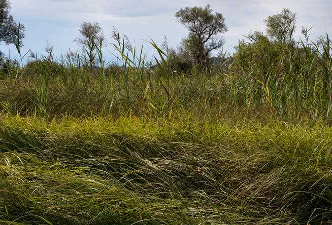
The Pfäffikersee is one of the largest water landscapes in the inventory.
According to Daniela Wegner, the total of 229 objects in the new inventory cover around a third of the entire canton. On the other hand, a lot has been left out. 136 objects from inventory 80 were no longer included because they were destroyed or no longer recognizable. A further 67 are redefined with changed perimeters.
Positive feedback from the communities
What does the new inventory do now? The head of the Office for Spatial Development, Wilhelm Natrup, emphasized that the Canton of Zurich now has a state-of-the-art landscape inventory; that creates legal certainty. The feedback from the communities was mostly positive.
Natrup confirmed that inclusion in the inventory is not equivalent to a building ban. An increased balancing of interests will apply to the area afterwards. In general, it is more possible to realize something in a cultural landscape. In a natural landscape, a change can hardly be undone.
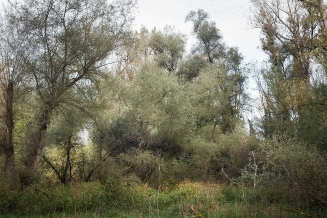
The Thurauen were upgraded years ago.
Natrup also said what the new inventory, while more resilient, cannot do. It does not affect agricultural management. Standard fruit trees are therefore not protected from being felled. A landscape protection area would have to be formally designated for this. The inventory also does not form a basis for funding contributions, for example for nature conservation.
However, Wilhelm Natrup expressed the hope that the inventory would improve public perception of the beauty of the landscapes and the value of their preservation. The head of department has established the inventory as provided for in the law. Because it has no direct impact on landowners, but is binding on the authorities, no appeals are possible against the determinations. This also applies to those objects in the old inventory that were not taken over.
Farmers’ Association warns
In the consultation, the Zurich Farmers’ Association (ZBV) and the environmental organizations made statements – for opposite reasons. Farmers fear restrictions. In a written statement, the ZBV is now demanding that agriculture in inventoried landscapes be fully recognized and allowed to develop according to common agricultural practice.
Andreas Hasler, Managing Director of Pro Natura Zurich, thinks the inventory is basically good: It is finally and for the first time an index of the formative landscapes. When asked, however, he complains that the protected areas are not also shown in the federal inventory.
On the Canton website for landscape protection you will find the link to the map with all objects. The respective object sheet can be called up here. It contains a description, the reason for inclusion in the inventory, the protection goals and mostly photographs. A separate 120-page report explains why objects from the old inventory were not included and why an objection from the hearing was not considered.
The reed landscape of the Pfäffikersee, in the background the settlement border to Wetzikon can be seen.
The inventory website provides an overview of the wealth of different landscapes in the canton of Zurich. Not all of them are as well known as the Albis chain, the Drumlins, the Zurich mountain area or the numerous rivers, lakes and wetlands. There is little known to discover, as some examples show:

From 1914, the Glatt was straightened almost entirely in several stages. Their fortified banks cut off alluvial forests and wetlands from the floods. There are a few old runs between Oberglatt and Rümlang right next to the airport runways. A meandering lowland river is rare in the canton of Zurich and, with its intact habitats, is extremely valuable in terms of landscape and ecology.

One of the most well-known legacies of the Linth Glacier are the elongated drumlins that were worn away by the ice. Sometimes, however, the glacier has formed a wide depression, as in the Hüsliriet near Bubikon. After its retreat, ice remained in it, which finally formed a so-called dead lake. Such lakes later silted up and today form a high or low moor.

The cultural landscapes include areas that are characterized by hedges and other woody elements. This includes a 256-hectare area above Schalchen in the municipality of Wildberg. In addition to numerous striking hedges, there are many fruit trees and a spacious tree-lined avenue. According to the entry in the inventory, this object provides a valuable insight into the wealth of forms of the traditional cultural landscape.

The Stammerberg on the border to the canton of Thurgau is not just an important mountain range. It is also intersected by historical paths that shaped the landscape. This includes the connection from Zurich to Stein am Rhein via Andelfingen. This in turn was only one section of the medieval long-distance trade route between Nuremberg and Lyon. What remains is the Fuchslen hollow path near Stammheim, which cannot be overlooked.